Runway Width
Runway width, the lateral dimension of a runway, is a critical airport planning parameter defined by regulatory standards (ICAO, FAA) to safely accommodate the ...
6 min read
Airport design
Runway engineering
+3
Lane width and runway width are fundamental geometric parameters affecting operational safety, capacity, and pavement marking layout. Width reduction from edge deterioration, vegetation encroachment, or shoulder drop-off is a recurring inspection finding. Covers width standards (AASHTO; ICAO Annex 14 runway width by code), measurement methods (tape; GPS; LiDAR; drone), and implications of width deficiency.

Lane width and runway width are the transverse dimensions of the paved surface intended for vehicular or aircraft traffic, measured perpendicular to the direction of travel. For highways, lane width is the distance between lane boundary markings or between a lane marking and the pavement edge. For airfields, runway width is the distance between runway edges — defined by ICAO as the width of the paved runway surface excluding shoulders. These geometric parameters are fundamental to operational safety, capacity, pavement design, and marking layout.
The importance of width extends beyond simple dimensional compliance. Width determines the lateral clearance available between vehicles or aircraft and pavement edges, between opposing traffic streams, and between vehicles and fixed obstacles. Inadequate width reduces the margin for driver or pilot error, constrains maneuverability, and increases crash risk. Width deficiency is a recurring inspection finding on both highways and airfields, caused by edge deterioration, vegetation encroachment, shoulder erosion, and structural deformation.
For highway infrastructure, lane width directly affects roadway capacity, operating speed, and crash frequency. Research from the Highway Capacity Manual (HCM 2010) shows that lane width reductions below 10 ft (3.05 m) produce measurable decreases in saturation flow rate. The AASHTO Green Book (Policy on Geometric Design of Highways and Streets) provides lane width guidance by functional class, with wider lanes (12 ft / 3.6 m) specified for high-speed, high-volume routes and narrower lanes (9-10 ft / 2.7-3.05 m) permitted for low-speed, constrained environments.
For airfield infrastructure, runway width is a critical parameter defined by the ICAO Aerodrome Reference Code. Width directly affects aircraft clearance margins during crosswind landings, turning operations, and ground maneuvering. ICAO Annex 14 Volume I establishes Standards and Recommended Practices (SARPs) that determine runway width based on the Outer Main Gear Wheel Span (OMGWS) and Code Number. Runway width deficiency — from edge raveling, shoulder drop-off, or vegetation overgrowth — reduces the safety margin for landing deviations and can generate foreign object debris (FOD) from deteriorating edges.
The AASHTO Green Book (Policy on Geometric Design of Highways and Streets) is the authoritative reference for lane width standards in the United States. The Green Book provides recommended ranges rather than rigid mandates, with the understanding that minimum values are implied by the lower end of each range. The guidance is structured by functional class — a hierarchical classification system that categorizes roadways by their role in the transportation network.
For rural roadways, lane width ranges are defined as follows: Freeways (Interstate) require 12 ft (3.6 m) as the uniform standard. No variation is permitted for freeways regardless of traffic volume or speed. Rural arterials range from 10 to 12 ft (3.05 to 3.6 m), with 12 ft used where practical on higher-speed, free-flowing principal arterials. Rural collectors range from 10 to 12 ft, and local roads from 9 to 11 ft (2.7 to 3.35 m). On low-volume rural roads (fewer than 400 vehicles per day), 9 ft lanes may be acceptable with documented design exceptions.
For urban roadways, freeways again require 12 ft lanes uniformly. Urban arterials range from 10 to 12 ft, with 11 ft commonly used for urban arterial street designs and 10 ft permitted in constrained areas where truck and bus volumes are low and speeds are at or below 35 mph. Urban collectors range from 10 to 12 ft. Urban local streets range from 10 to 12 ft, but 9 ft lanes can be used in residential areas where right-of-way width imposes severe limitations. The Green Book explicitly states that “9 ft lanes can be used in residential areas where the available or attainable width of right-of-way imposes severe limitations.”
| Roadway Type | Context | Lane Width Range | Metric Equivalent |
|---|---|---|---|
| Interstate Freeway | Rural / Urban | 12 ft | 3.6 m |
| Principal Arterial (high-speed) | Rural | 11-12 ft | 3.35-3.6 m |
| Principal Arterial (constrained) | Urban, ≤ 35 mph | 10-11 ft | 3.05-3.35 m |
| Minor Arterial | Rural / Urban | 10-12 ft | 3.05-3.6 m |
| Collector | Rural / Urban | 10-12 ft | 3.05-3.6 m |
| Local Street | Urban | 10-12 ft (9 ft residential) | 3.05-3.6 m (2.7 m) |
| Low-Volume Road (< 400 vpd) | Rural | 9-11 ft | 2.7-3.35 m |
The relationship between lane width and roadway capacity has been extensively studied. The Highway Capacity Manual (HCM 2010) found no reduction in lane capacity until lane width is less than 10 ft. For lane widths between 10 ft and 13 ft, saturation flow adjustments are eliminated entirely — meaning capacity is statistically identical across this range. HCM research documented that for lane widths below 10 ft, capacity reductions range from 2 to 6 percent depending on width.
Research from NCHRP Report 330 — “Effective Utilization of Street Width on Urban Arterials” (1990) — concluded that narrower lane widths (less than 11 ft) can be used effectively in urban arterial street improvement projects. All projects evaluated with 10 ft lanes or more resulted in accident rates that were either reduced or unchanged. A subsequent safety evaluation by Potts, Harwood, and Richard (Transportation Research Record Vol. 2023, 2007) found that lane width effects were generally either not statistically significant or indicated that narrower lanes were associated with lower rather than higher crash frequencies under urban conditions. The exceptions were 10 ft or narrower lanes on four-lane undivided arterials and 9 ft or narrower lanes on four-lane divided arterials.
Standard highway design vehicles have a width of 8.5 ft (2.6 m) per the Surface Transportation Assistance Act of 1982. Lane width must accommodate these vehicles with adequate lateral clearance. For standard mixed-traffic highways, 12 ft (3.6 m) lanes provide approximately 1.75 ft (0.5 m) of clearance on each side of a truck. For exclusive truck facilities, the desired lane width increases to 13 ft (4.0 m) — calculated as 8.5 ft vehicle width plus 2 ft right clearance plus 2.5 ft left clearance (per Transportation Research Record 1026). High truck volume routes (over 30 percent trucks) should maintain 12 ft minimum lane widths. Moderate truck volume routes (10 to 30 percent) can use 11 ft minimum, and low truck volume routes (under 10 percent) can use 10 ft minimum.
The AASHTO Green Book explicitly permits lane width reduction in constrained environments. The NACTO Urban Street Design Guide recommends that “lane widths of 10 feet are appropriate in urban areas and have a positive impact on a street’s safety without impacting traffic operations.” NACTO further states that “lanes greater than 11 feet should not be used as they may cause unintended speeding and assume valuable right-of-way at the expense of other modes.” For designated truck and transit routes, one travel lane of 11 ft may be used in each direction.
Lane width is one of the 13 controlling criteria for FHWA design exceptions on the National Highway System. Reducing lane width below the minimum requires documentation of the degree of reduction, exposure assessment (segment length, traffic volumes, duration), context identification (social, economic, environmental impacts), risk mitigation measures (shoulders, speed reduction, signage improvement), and structured risk assessment approval.
Runway width per ICAO Annex 14 Volume I is determined by the Aerodrome Reference Code, which consists of two elements: Code Number (based on aeroplane reference field length) and Code Letter (based on wingspan). However, runway width specifically depends on Code Number and Outer Main Gear Wheel Span (OMGWS) — not directly on Code Letter. This distinction was formally established in Amendment 14 to Annex 14 (2020), which decoupled wingspan from OMGWS for pavement width determination.
Code Number is determined by aeroplane reference field length: Code 1 applies to field lengths less than 800 m, Code 2 applies to 800 m up to but not including 1200 m, Code 3 applies to 1200 m up to but not including 1800 m, and Code 4 applies to 1800 m and over. Code Letter is determined by wingspan: Code A applies to wingspans up to but not including 15 m, Code B applies to 15 m up to but not including 24 m, Code C applies to 24 m up to but not including 36 m, Code D applies to 36 m up to but not including 52 m, Code E applies to 52 m up to but not including 65 m, and Code F applies to 65 m up to but not including 80 m.
ICAO Annex 14, Section 3.1.10, defines runway width as a function of Code Number and OMGWS. The following table presents the standard runway width values:
| Code Number | OMGWS < 4.5 m | OMGWS 4.5 m to < 6 m | OMGWS 6 m to < 9 m | OMGWS 9 m to < 15 m |
|---|---|---|---|---|
| 1 | 18 m | 18 m | 23 m | — |
| 2 | 23 m | 23 m | 30 m | — |
| 3 | 30 m | 30 m | 30 m | 45 m |
| 4 | — | — | 45 m | 45 m |
Key clarifications from ICAO Annex 14 and Doc 9157 Part 1 (Aerodrome Design Manual — Runways):
Precision approach exception: For Code Numbers 1 and 2, where the runway is a precision approach runway (Category I, II, or III), the width must be not less than 30 m regardless of OMGWS. This ensures adequate lateral clearance for instrument approach operations where landing deviations are more tightly controlled but the consequences of edge excursion are more severe.
Code Number 4 and Code Letter F: Prior to Amendment 14, Code F runways required 60 m width. Amendment 14 reduced this to 45 m for OMGWS 9 to 15 m based on actual landing deviation studies showing that Code F aircraft deviate less from centerline than previously assumed. Shoulders are added to bring total runway-plus-shoulder width to 60 m for 2- or 3-engined aeroplanes and 75 m for 4- or more-engined aeroplanes.
Wingspan vs. OMGWS rationale: Amendment 14 decoupled the two dimensions. Wingspan remains relevant for separation distances (obstacle limitation surfaces, strip widths, runway-taxiway separation). OMGWS impacts ground-based maneuvering characteristics (runway width, taxiway width, turn pad clearances). Using only the more demanding component previously caused overdesign. A Code F aircraft with a large wingspan (65-80 m) but OMGWS of 12 m now only needs a 45 m runway with shoulders rather than a full 60 m paved surface.
The runway strip — a defined area including the runway and any shoulders that extends beyond the runway ends — has width requirements that differ significantly from the runway pavement itself. For non-instrument runways, the strip extends 30 m each side of the centerline for Code 1, 40 m for Code 2, and 75 m for Code 3 and 4. For precision approach runways, the strip extends 140 m each side of the centerline for Code 3 and 4, and 70 m for Code 1 and 2.
Runway shoulder widths for Code Letters D, E, and F with OMGWS 9-15 m must bring the total width (runway plus shoulders) to 60 m for Code D or E. For Code F with 2- or 3-engined aeroplanes, the minimum total width is 60 m; for Code F with 4 or more engines, the minimum total width is 75 m. These shoulders are typically paved and designed to support occasional traffic and prevent engine ingestion of debris.
ICAO Annex 14 Section 3.5.5 requires that the width of a RESA be at least twice the width of the associated runway. For a Code 4 runway with 45 m width, the RESA must therefore be at least 90 m wide. This requirement links runway width directly to safety area geometry.
Taxiway width is also governed by ICAO Annex 14 and the Aerodrome Design Manual (Doc 9157 Part 2). Taxiway width is determined by the OMGWS of the design aircraft. The standard taxiway width for Code Letter C aircraft (Boeing 737, Airbus A320 family) is 15 m straight section width, increasing to 18 m or wider on curves to accommodate the turning path of the nose gear and the path of the main gear.
FAA standards (AC 150/5300-13B, Airport Design) define taxiway width by Airplane Design Group (ADG) . For ADG I (wingspan < 49 ft / 15 m), taxiway width is 25 ft (7.6 m). For ADG II (wingspan 49-79 ft / 15-24 m), width is 35 ft (10.7 m). For ADG III (wingspan 79-118 ft / 24-36 m), width is 50 ft (15.2 m). For ADG IV (wingspan 118-171 ft / 36-52 m), width is 75 ft (22.9 m). For ADG V (wingspan 171-214 ft / 52-65 m), width is 75 ft. For ADG VI (wingspan 214-262 ft / 65-80 m), width is 75 ft with wider fillets at turns.
Taxiway width directly affects wing tip clearance. FAA standards require a minimum wing tip clearance of 15 ft (4.6 m) from the taxiway edge for ADG III and above. When taxiway width is reduced due to edge deterioration or vegetation encroachment, this clearance margin is eroded, increasing the risk of wing tip contact with obstacles or terrain.
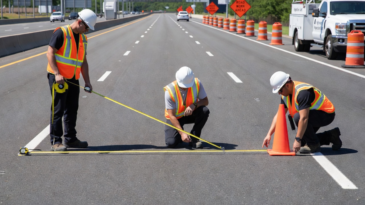
Accurate width measurement is essential for compliance verification, condition documentation, and maintenance planning. The choice of measurement method depends on accuracy requirements, corridor length, traffic conditions, and available resources. The following methods are available, each with distinct accuracy characteristics.
Calibrated steel tape measurement achieves the highest accuracy — ±1 to 3 mm per measurement under controlled conditions — but is labor-intensive and requires traffic closures. A NIST-calibrated surveyor’s tape (Class I or II) is accurate to ±1-2 mm per 30 m under standard conditions (20 °C, 50 N tension, fully supported). Error sources include temperature variation (steel thermal expansion of 0.7 mm per 30 m per 5 °C deviation), non-standard tension (0.3-1.0 mm per 30 m per 10 N error), sag (1-5 mm per 30 m depending on tension), slope (1 mm per 30 m per 0.5-degree slope), and parallax reading error (±2-5 mm typical). For pavement width measurement on an active runway or highway, tape measurement is impractical because it requires physical access to both edges simultaneously. It is best suited for spot checks, quality control on fresh pavement, and narrow roadways under 10 m width.
The surveyor’s measuring wheel achieves ±0.2 percent accuracy under ideal smooth, hard, level surfaces — approximately ±7.6 mm per 30 m. In real-world conditions on asphalt with slight unevenness, accuracy degrades to ±0.5-1.0 percent (±1-3 cm per 30 m width). Over rough surfaces, errors can exceed ±2-3 percent. Error sources include tire slip (up to 5 percent on loose aggregate), surface unevenness causing wheel bounce (1-3 percent), non-straight path (systematic under- or over-estimation), tire wear and pressure changes (±0.5-2 percent), and obstacles requiring wheel lifting (±1-5 cm per event). The measuring wheel is suitable for preliminary estimates and construction quantity verification where ±2-5 cm accuracy is acceptable.
Standard code-phase GPS achieves ±3-10 m horizontal accuracy (95 percent confidence), which is insufficient for pavement width measurement as it cannot reliably distinguish lane edges. Differential GPS (DGPS) achieves ±0.1-1.0 m (typically ±30-50 cm), which is marginal for width measurement. Real-Time Kinematic (RTK) GPS/GNSS achieves ±1-2 cm horizontal accuracy under best conditions with a baseline limit of approximately 35 km from the base station. RTK requires unobstructed sky view — tree canopy or urban canyons degrade accuracy significantly. For width measurement, RTK requires physically occupying both pavement edges with a rover, which is time-consuming for corridor-length surveys. Multipath interference from pavement surfaces and adjacent structures degrades accuracy by 2-5 cm near large structures.
Mobile LiDAR scanning mounted on a vehicle captures point clouds with densities of 500 to 5,000 points per square meter (mobile mapping) or up to 50,000 points per square meter (static scanning). Individual point accuracy ranges from ±2-10 mm (static) to ±5-20 mm (mobile mapping). Width measurement accuracy after edge extraction is typically ±1-3 cm. To resolve a pavement edge to ±1 cm, a minimum of 50-100 points per square meter is needed at the edge transition. The LiDAR workflow includes georeferencing, strip alignment (correcting drift between swaths through boresight calibration), noise filtering (removing vegetation and vehicles), ground classification, edge extraction from elevation change or intensity gradients, and width calculation between extracted edges. Equipment cost ranges from $50,000 to $500,000 for professional systems. Processing time ranges from hours to days for corridor-length datasets.
Aerial (Drone-mounted) LiDAR achieves point cloud densities of 50-500 points per square meter with vertical accuracy of ±2-5 cm (with RTK/PPK and ground control) and horizontal accuracy of ±3-8 cm. Swath overlap of 20-50 percent is recommended for uniform coverage.
Drone orthophotogrammetry produces a georeferenced, distortion-free 2D orthomosaic from overlapping aerial images from which pavement width can be measured directly. The key parameter is Ground Sample Distance (GSD) — the real-world area represented by one pixel. GSD is calculated as:
GSD = (Flight Altitude × Sensor Height) / (Focal Length × Image Height)
Typical GSD values: at 50 m altitude with a 20 MP sensor, GSD is approximately 1.2 cm/pixel; at 100 m altitude with a 20 MP sensor, GSD is 2.4 cm/pixel; at 120 m altitude with a 61 MP sensor, GSD is 1.9 cm/pixel.
Accuracy depends on georeferencing method. Photogrammetry without ground control points (using only drone GPS) achieves ±5-20 m horizontal accuracy — insufficient for width measurement. Photogrammetry with RTK/PPK drone positioning achieves ±3-8 cm. Photogrammetry with RTK plus ground control points (GCPs) achieves ±1-4 cm horizontal accuracy. A study published in MDPI Remote Sensing comparing photogrammetric and RTK-GPS methods found UAV photogrammetry reliably accurate within 41 mm horizontal and 68 mm vertical with RTK.
Key accuracy factors include image overlap (75-80 percent frontlap, 65-75 percent sidelap minimum for road corridors), GCP density (4-6 per project area improves absolute accuracy by a factor of 10), surface texture (pavement with striping provides good contrast; uniform dark asphalt is poor), lighting conditions (overcast diffuse light is best; harsh shadows degrade edge definition), vegetation overhang (obscures pavement edges), and camera quality (61 MP full-frame sensors outperform 20 MP 1-inch sensors by 2-3 times).
In practice, measurement uncertainty is 2-3 times GSD — meaning a 2 cm GSD orthophoto produces width measurements with ±3-6 cm uncertainty. This is acceptable for most pavement condition documentation and compliance verification where width tolerance is typically ±15-30 cm.
| Method | Typical Accuracy | Best Case | Cost | Traffic Closure |
|---|---|---|---|---|
| Tape measure | ±2-10 mm | ±1-2 mm | Low | Yes |
| Measuring wheel | ±1-5 cm | ±0.3% | Very low | Yes |
| Standard GPS | ±3-10 m | ±3 m | Low | No |
| DGPS | ±30-100 cm | ±10 cm | Moderate | No |
| RTK GPS rover | ±2-5 cm | ±1 cm | Moderate | Yes (to occupy edges) |
| Mobile LiDAR | ±1-3 cm | ±5 mm | High | No |
| Drone LiDAR | ±2-5 cm | ±1 cm | High | No |
| Drone photogrammetry (RTK+GCPs) | ±2-5 cm | ±1.5 cm | Moderate | No |
Pavement width reduction is a progressive, multi-mechanism process. The following causes are documented in pavement engineering literature and recurring inspection findings.
Edge raveling is the progressive loss of asphalt binder and aggregate particles from the pavement surface inward, beginning at the pavement edge and migrating toward the wheelpath. The mechanism involves binder oxidation and aging from UV exposure and thermal cycling at the exposed vertical edge face, loss of edge confinement (unlike interior pavement, the edge has no lateral support), and traffic-induced tensile stresses that fracture the aged binder. Once the binder fails, individual aggregate particles break free, initiating a chain reaction as each successive row of aggregate loses its surrounding binder matrix.
Severity is classified by width from edge: low severity involves loss of fines only (less than 1 in / 2.5 cm), moderate severity involves coarse aggregate loss with irregular edge (1-6 in / 2.5-15 cm), and high severity involves significant aggregate loss with structurally compromised edge (greater than 6 in / 15 cm). Accelerating factors include inadequate edge compaction during construction (lower density equals higher permeability), moisture intrusion at the edge (freeze-thaw cycles exacerbate separation), snowplow mechanical abrasion, and vegetation root pressure.
Shoulder drop-off is a vertical differential in elevation between the travel lane surface and the shoulder surface. Research by Zimmer and Ivey, Glennon, and Klein et al. established critical height thresholds. Drop-off heights of 1-2 in (2.5-5 cm) produce moderate risk where scrubbing begins and loss of control is possible above 30 mph. Heights of 2-3 in (5-7.6 cm) produce high risk with documented loss of control. Heights of 3-4.5 in (7.6-11.4 cm) produce very high risk where 53 percent of tests produced scrubbing and 56 percent of those exceeded a 12-ft lane. Heights exceeding 6 in (15 cm) produce severe risk of rollover from undercarriage contact.
The primary risk mechanism is the scrubbing reentry hazard: a vehicle departs the paved surface at a shallow angle; the tire contacts the vertical drop-off face; sidewall-to-edge friction resists remounting; the driver increases steering angle, building lateral force; when the wheel finally mounts the edge, the accumulated steer angle produces a slingshot effect with rapid lateral acceleration across adjacent lanes. AASHTO and FHWA guidance specifies that no vertical drop-off greater than 3 in (7.6 cm), or greater than 4.5 in (11.4 cm) with a 45-degree face, should be left unprotected overnight.
Vegetation encroachment on runway and taxiway edges occurs through lateral growth of grass, weeds, and shrubs onto paved surfaces; root penetration undermining pavement structure causing edge cracking and heaving; and vertical growth near edges obscuring markings and lighting. FAA standards require turf within runway and taxiway safety areas to be maintained at 6-12 inches (15-30 cm) height, with a vegetation-free zone adjacent to pavement edges for FOD control and visual clarity. Integrated Vegetation Management (IVM) plans combine mowing, selective herbicides, and plant growth regulators (PGRs).
Consequences of vegetation encroachment include reduced effective pavement width (narrowing usable area), interference with Instrument Landing System (ILS) signals and PAPI lights from tall grass, wildlife attraction (habitat for birds and animals), FOD generation (seeds, plant debris, mower clippings), pavement damage from root infiltration into joints and cracks, and drainage impairment from clogged edge drains.
Rutting is the longitudinal surface depression in the wheelpath caused by permanent deformation of pavement layers. Three types are recognized: densification (air void reduction under compaction from traffic), shear deformation (lateral movement of asphalt mix under wheel load), and subgrade rutting (excessive vertical strain reflecting through all layers). The effect on effective pavement width is significant: rut shoulders (upheaval adjacent to the depressed wheelpath) reduce the usable flat surface width. On a 12-ft lane with 1-in-deep ruts, the effective travelable width may be reduced by 6-12 in (15-30 cm) per wheelpath due to the deformed cross-slope. Water ponds in ruts, creating hydroplaning risk. Rutting greater than 0.5 in (12.7 mm) is considered a serviceability failure for most highway agencies. For runways, FAA AC 150/5370-10 specifies a maximum rutting depth of 0.5 in for operational safety.
Width deficiency on highways increases run-off-road (ROR) crash frequency, sideswipe risk, and head-on collision probability. Research from the FHWA Highway Safety Manual (HSM) establishes Crash Modification Factors (CMFs) for lane widening. Widening from 9 ft to 11 ft on two-lane rural highways produces a CMF of approximately 0.70 to 0.85 — a 15-30 percent crash reduction. Adding paved shoulders of 4-8 ft produces CMFs of 0.60 to 0.80 for ROR crashes. On two-lane highways, lane width reduction from 12 ft to 10 ft is associated with a 10-20 percent increase in total crashes on rural roads.
Heavy vehicles are disproportionately affected by width deficiency. A standard 8.5-ft-wide truck in a 9-ft lane has only 2-3 in (5-7.6 cm) of clearance on each side — insufficient for lateral sway at speed. Drivers compensate for narrow lanes by reducing speed and increasing lateral position variance, which can produce greater speed differentials between vehicles and raise passing-related crash risk.
Width deficiency on runways reduces the lateral margin available for cross-wind corrections and landing deviations. Research from ICAO flight data analysis shows that a 3-degree crab angle on landing can place wing tips outside the paved surface within 10-15 ft (3-4.6 m) of lateral drift. Reduced pavement width constrains aircraft turning radius, increasing potential for nose gear excursion during 180-degree turns. Edge raveling generates foreign object debris (FOD) from loose aggregate — jet engine ingestion of debris weighing more than 2 oz (57 g) can cause catastrophic engine failure. Inoperative edge lights resulting from base failure due to edge deterioration reduce nighttime visibility. Width deficiency implies non-compliance with ICAO Annex 14 strip dimensions and safety area requirements, affecting aerodrome certification.
Width deficiency directly affects pavement marking placement and visibility. When pavement width is reduced due to edge deterioration, edge lines must be placed closer to the physical edge or omitted. The reduced lateral distance between centerline and edge line compresses the driver’s or pilot’s visual field, reducing preview time to detect curvature. Research from the Texas Transportation Institute (TxDOT Report 0-5862-1) found that wider edge lines (6 in vs. 4 in) produce measurable improvements in driver lateral placement, shifting drivers away from centerline by 2-4 in (5-10 cm) on curves. When edge lines cannot be maintained at their designed offset from the pavement edge due to width deficiency, these safety benefits are lost.
Vegetation overgrowth at pavement edges obscures edge lines, physically covering markings. Rutting alters the marking plane angle, reducing retroreflectivity as the headlight angle relative to the marking changes. Raveling at edges destroys the edge line substrate, making it impossible to maintain retroreflective beads in the marking.

Drone orthophotogrammetry is emerging as the preferred method for corridor-scale pavement width measurement, particularly for condition documentation and asset inventory. The method offers a favorable combination of accuracy (sub-5 cm with proper GCPs), speed (30 minutes to survey a 10,000-ft runway), and safety (no traffic closures required).
The drone width measurement workflow comprises five stages. Mission planning defines the flight area, altitude (typically 50-120 ft / 15-37 m for pavement surveys), image overlap (80 percent forward, 70 percent side overlap minimum), and GSD target (1-2 cm/pixel). Flight paths are programmed using ground control station software to maintain consistent lighting and avoid shadowing. Data acquisition uses a multi-rotor UAV with RTK GPS positioning — typically a DJI Phantom 4 RTK, Matrice 300/350 RTK, or WingtraOne — equipped with a 20-61 MP camera. Images are captured in nadir (vertical) orientation with geotags from the RTK receiver.
Photogrammetric processing uses Structure from Motion (SfM) software such as Pix4Dmatic, Agisoft Metashape, or DJI Terra to stitch overlapping images into a seamless orthomosaic and digital surface model (DSM). The orthomosaic is georeferenced to the local coordinate system using GCPs or RTK-derived positions. Width measurement is performed in GIS or CAD software by digitizing pavement edge lines and measuring perpendicular distances between them at user-defined intervals. Measurement can be automated through edge detection algorithms that identify pavement edges from color contrast, elevation change, or intensity gradients in the orthomosaic.
Condition reporting outputs width measurements at specified chainages with summary statistics (minimum, maximum, mean, standard deviation). Widths below threshold are flagged for follow-up inspection or maintenance action. The georeferenced orthomosaic provides a permanent visual record that can be compared with future surveys to track width change over time.
Width measurement from drone orthophotos depends on GSD, georeferencing accuracy, and edge definition. GSD determines the pixel resolution on the ground — at 1 cm/pixel GSD, the minimum measurable width change is approximately 1 cm, but practical measurement uncertainty is 2-3 cm (2-3 pixels). Georeferencing accuracy determines whether the orthomosaic correctly represents real-world coordinates. With RTK drone positioning plus GCPs, absolute accuracy of ±2-4 cm is achievable. Edge definition uncertainty is often the dominant error source — the transition between pavement and shoulder can span 5-15 cm of ambiguous surface where the pavement edge is not clearly defined.
Drone orthophoto width measurement offers several advantages over ground-based methods. No traffic closures are required — the drone flies above the facility without disrupting operations. Complete coverage is provided — every meter of pavement is captured in the orthomosaic, unlike spot measurements with tape or measuring wheel. Permanent record is created — the orthomosaic can be archived and compared with future surveys for change detection. Integration with GIS allows width measurements to be combined with other pavement condition data (cracking, rutting, raveling) in a single georeferenced database. Repeatable methodology ensures consistent measurement criteria across surveys and between different operators.
Width inspection is a recurring element of both highway and airfield pavement condition assessment programs. For highways, width is typically measured as part of pavement condition index (PCI) surveys (ASTM D5340 for airfields, ASTM D6433 for roads) and roadway geometric inventory. For airfields, width is verified during airfield self-inspections required under 14 CFR Part 139 and during aerodrome certification audits per ICAO Annex 14.
For highways, geometric inventory surveys including lane width are typically conducted every 2-5 years depending on agency policy. Pavement condition surveys that include edge deterioration assessment are conducted annually or biennially. For airfields, daily self-inspections include visual assessment of pavement edge condition and width-related distress. Comprehensive PCI surveys including width measurement are conducted every 3-5 years per ASTM D5340.
Visual inspection by a trained inspector driving or walking the facility identifies edge raveling, shoulder drop-off, vegetation encroachment, and rutting that reduce effective width. Measurement-based inspection uses tape, measuring wheel, or GPS to quantify width at representative sampling locations. Drone-based inspection provides full-coverage width measurement as described above.
For highways, the threshold for width deficiency is the design lane width minus the acceptable tolerance. A 12-ft lane (3.6 m) with edge raveling extending 6 in (15 cm) inward reduces the effective lane width to 11.5 ft (3.5 m). If the design standard requires 11 ft minimum, the lane remains acceptable but should be monitored. If the standard requires 12 ft, the deficiency requires documentation and remediation planning.
For runways, width deficiency is evaluated against ICAO Annex 14 requirements. A Code 4 precision approach runway requiring 45 m width that has lost 1 m from each edge to raveling has an effective width of 43 m — a non-compliance finding requiring corrective action. The Aeronautical Information Publication (AIP) must be updated to reflect the reduced declared width if the deficiency cannot be immediately corrected.
Edge repair addresses localized width loss from raveling and edge deterioration. Methods include hand patching (manual application of cold-mix or hot-mix to localized broken edges for small isolated areas), shoulder reshaping (grading existing shoulder material toward pavement to restore flush condition for unpaved shoulders with on-site material), replenishing with select borrow (importing granular material to rebuild eroded shoulder for severely eroded shoulders), and rebuilding on crown base (full reconstruction of pavement edge including milling, subgrade preparation, and HMA placement for roads with significant structural edge failure).
The Safety Edge — a 30-45 degree tapered pavement edge applied during overlay — is an FHWA Every Day Counts (EDC) initiative that eliminates the vertical drop-off condition. Research demonstrates that Safety Edge reduces the scrubbing reentry hazard and extends pavement edge life by improving compaction at the edge.
Shoulder restoration addresses width deficiency from shoulder drop-off and erosion. The TxDOT research (Report 0-4396-1 by Lawson and Hossain) established a cost-effectiveness continuum for shoulder maintenance. Least expensive and shortest lasting methods include vegetation control, crack sealing, and edge sealing. Moderately expensive methods include hand patching, shoulder reshaping, and edge restoration with borrow material. The most expensive but longest lasting method is road widening with paved shoulders, which adds paved shoulders (typically 4-10 ft / 1.2-3 m per side), eliminates the edge drop-off condition entirely, provides structural support to the travel lane edge, improves sight distance, and reduces crash frequency by 30-50 percent for ROR crashes.
Preventive edge maintenance methods include raw edging (mechanical cutting of overgrown vegetation at pavement edge to prevent root damage and maintain drainage), edge sealing (application of asphalt binder or emulsion along the pavement edge 6-12 in / 15-30 cm wide to seal unprotected edge and prevent water intrusion), approach aprons (paved transitions at driveways and intersections to reduce edge abrasion from turning vehicles), and vegetation management (mowing, herbicide application, and plant growth regulators to prevent biological encroachment).
The fundamental principle in width maintenance is captured by what is known as Tracy’s Law in pavement engineering: “If you lose the edge, you lose the road.” Edge neglect is the primary mechanism by which pavement width is progressively reduced, and timely edge maintenance is the most cost-effective intervention to preserve full pavement width.
Lane and runway width are fundamental input parameters in pavement structural design. The design width determines the traffic loading area, which affects the required pavement thickness and material properties. In the AASHTO Pavement Design Guide (Mechanistic-Empirical or 1993 version), lane width is used to compute equivalent single axle load (ESAL) distribution across the pavement cross-section. Wider lanes spread traffic loading over a larger area, reducing the load concentration per unit width and potentially extending pavement life.
For airfield pavement design, runway width determines the transverse distribution of aircraft loading. The FAA Flexible Pavement Design method (FAA AC 150/5320-6G) and ICAO Pavement Design Manual use the width of the runway or taxiway to compute the number of gear passes at each lateral position. A wider runway allows greater lateral wander of aircraft, distributing gear loads over a larger pavement area and reducing the maximum coverages at any single point. The wander width assumption in pavement design is typically 1.5-2.0 m for runways and 0-0.5 m for taxiways (where aircraft track closely along the centerline).
Width also affects pavement drainage. Wider pavements generate greater runoff volumes per unit length, requiring larger drainage infrastructure (gutters, inlets, culverts). The pavement cross-slope (typically 1.5-2 percent for highways, 1-1.5 percent for runways) works with width to determine the flow path length and sheet flow depth. Width reduction from edge deterioration can alter the effective drainage flow path, potentially causing ponding at the pavement edge.
The primary standards governing lane and runway width are:
The relationship between these standards is hierarchical. ICAO Annex 14 establishes international SARPs adopted by 193 member states. National authorities (FAA, EASA, CASA) issue regulations and advisory documents implementing ICAO standards. Facility-specific design criteria are established by facility operators (airport authorities, state DOTs, municipal agencies) within the framework provided by these higher-level standards. Compliance is verified through regular inspection, aerodrome certification audits, and design exception documentation.
TarmacView helps infrastructure operators measure lane and runway widths from drone orthophotos with sub-5 cm accuracy. Schedule a demo to see how digital width measurement supports condition documentation and safety compliance.
Runway width, the lateral dimension of a runway, is a critical airport planning parameter defined by regulatory standards (ICAO, FAA) to safely accommodate the ...
Runway length is the measured distance between the two runway ends, essential for airport planning and aircraft operations. It determines which aircraft an airp...
A runway strip is a defined rectangular area surrounding a runway and stopway at an aerodrome, designed to minimize the risk of damage to aircraft during runway...