What is Rain in Aviation Meteorology?
Rain – Aviation Glossary: Precipitation of Water Droplets in Meteorology
Rain is one of the most familiar and operationally significant weather phenomena in aviation. Its presence, type, and intensity influence every aspect of flight, from visibility and instrument approach minima to runway surface conditions and aircraft performance. This entry provides a comprehensive overview of rain in meteorology, with a special focus on its relevance to aviation safety, operations, and weather reporting.
Definition and Relevance in Aviation
Rain is defined in meteorology as precipitation composed of liquid water droplets with diameters greater than 0.5 millimeters (0.02 inches), falling from clouds and reaching the ground. This threshold, established by the International Civil Aviation Organization (ICAO) and World Meteorological Organization (WMO), is critical for standardizing weather reporting and operational procedures. Precipitation with smaller droplets is classified as drizzle (DZ), which has distinct operational implications for pilots and air traffic controllers.
In aviation, the ability to distinguish rain from other types of precipitation (such as drizzle, snow, or hail) is essential. Rain affects runway braking action, reduces visibility, impacts the reliability of navigation aids, and can trigger low-visibility and contaminated runway procedures. Its accurate identification and reporting underpin flight safety and efficiency across all phases of flight, from departure to arrival.
Rain as a Form of Precipitation
Precipitation encompasses all water, in liquid or solid form, that falls from the atmosphere to the Earth’s surface. Rain is the most common type, especially in mid-latitude and tropical regions. In aviation meteorology, rain is typically associated with two cloud types:
- Nimbostratus: Producing steady, stratiform rain, often leading to persistent low ceilings and reduced visibility.
- Cumulonimbus: Responsible for convective rain, which is more intense, variable, and often accompanied by turbulence, windshear, and thunderstorms.
The type and source of rain influences the operational response at airports, the likelihood of weather-related delays, and the safety of flight operations during approach, landing, and takeoff.
Physical Characteristics of Raindrops
Size and Shape
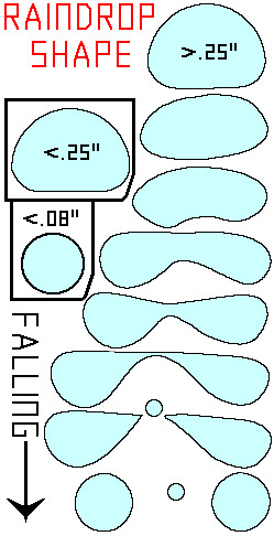
Raindrops vary in diameter from the minimum threshold for rain (0.5 mm) up to about 6 mm. Drops larger than 6 mm become aerodynamically unstable and tend to break apart before reaching the surface. The morphology of raindrops evolves with size:
- Small drops (<1 mm): Nearly spherical, maintained by surface tension.
- Medium drops (2–3 mm): Oblate, with a flattened base and bulged sides, resembling a hamburger bun.
- Large drops (>4 mm): Parachute-shaped and unstable, prone to fragmentation.
These physical properties are significant for aviation because they determine how rain interacts with weather radar (affecting reflectivity and rainfall rate estimation) and influence the attenuation of aircraft navigation and communication signals in heavy rain.
Raindrop Evolution and Terminal Velocity
Raindrops originate as tiny cloud droplets (~0.02 mm) and grow larger through condensation and the collision–coalescence process. As they descend, larger drops fall faster, sweeping up smaller ones. The terminal velocity of a raindrop depends on its size: a 0.5 mm drop falls at about 2 m/s, a 2 mm drop at 6.7 m/s, and a 5 mm drop at 9 m/s. These velocities are relevant for understanding windshear, microbursts, and the onset of heavy rainfall near airports.
Raindrop Size Distribution
Rain is not composed of uniformly sized droplets. The raindrop size distribution describes the statistical spread of drop diameters in a rain event and is usually modeled using a gamma function or the Marshall-Palmer exponential distribution. Understanding this distribution is vital for calibrating weather radar, interpreting dual-polarization radar data, and improving rainfall rate estimates for airport drainage and runway safety assessments.
Mechanisms of Rain Formation
Cloud Droplet Formation
Cloud droplets form when water vapor condenses onto cloud condensation nuclei (CCN), small particles like dust, salt, or smoke. The concentration and nature of CCN influence cloud properties and the likelihood of rain. High CCN counts, common near cities and airports, can suppress rain by creating many small droplets that have difficulty growing large enough to fall as rain.
Condensation and Coalescence
Growth by condensation is limited, so further enlargement of cloud droplets to raindrop size mainly occurs through collision–coalescence: larger drops fall faster and collect smaller ones as they descend. This process is efficient in clouds with a broad range of droplet sizes and is responsible for most warm rain events, particularly in tropical and maritime environments.
The Bergeron-Findeisen Process
In cold clouds containing both supercooled water and ice crystals, the Bergeron-Findeisen process dominates. Ice crystals grow at the expense of supercooled droplets and eventually fall, melting into rain if they pass through a layer of above-freezing air. This is typical of stratiform rain in mid-latitudes and is crucial for predicting freezing rain and icing hazards in aviation.
Types of Rain and Classification Criteria
Distinguishing Rain from Drizzle
The distinction is based on droplet size:
| Parameter | Rain (>0.5mm) | Drizzle (<0.5mm) |
|---|---|---|
| Drop Diameter | >0.5 mm | <0.5 mm |
| Appearance | Large, fast-falling drops | Fine, floating drops |
| Visibility | Less impact than drizzle | Strongly reduces visibility |
| METAR Code | RA | DZ |
Correct classification is essential for weather reports, approach minima, and ground operations.
Intensity Classifications
Rainfall intensity is categorized by rate, affecting operational responses:
| Intensity | Rate (mm/hr) | Description |
|---|---|---|
| Light | 0.25–2.5 | Minimal impact, surfaces wet slowly |
| Moderate | 2.5–7.5 | Steady rain, visibility reduction |
| Heavy | >7.5 | Rapid accumulation, possible flooding |
| Very Heavy | >25 | Downpours, airport drainage overwhelmed |
The ICAO and WMO standardize these classes for global consistency.
Showers, Stratiform Rain, and Freezing Rain
- Showers: Sudden, intense bursts from cumuliform clouds, often localized.
- Stratiform rain: Steady, widespread, from layered clouds.
- Freezing rain: Rain that freezes on contact with cold surfaces, forming a dangerous glaze, critical for airport and aircraft operations in winter.
Measurement of Rain
Instruments and Techniques
- Rain Gauges: Manual and automated (tipping-bucket, weighing) gauges at airports provide continuous rainfall and intensity data.
- Weather Radar: Detects and estimates rain coverage, intensity, and type. Dual-polarization radar distinguishes liquid from frozen precipitation.
- Satellite Remote Sensing: Complements ground observations, especially over oceans and remote regions.
Point and Areal Measurements
- Point measurement: Rainfall at a specific location (e.g., at a runway gauge).
- Mean Areal Precipitation (MAP): Average over an area, important for airport drainage and flood risk assessment.
Challenges
Rainfall is variable, gauge placement, wind, evaporation, and radar beam attenuation can affect measurements. Accurate data is essential for operational decisions, and standardized procedures are mandated by ICAO to ensure reliability.
Rain in the Water Cycle and Airport Operations
Role in the Hydrologic Cycle
Rain is the main mechanism by which atmospheric water returns to the surface, replenishing rivers, lakes, and groundwater. For airports, this means:
- Stormwater Management: Sufficient drainage must prevent runway and taxiway flooding.
- Water Supply: Rainfall supports local water tables and fire suppression systems.
- Environmental Impact: Understanding rain patterns helps airports manage runoff and comply with environmental regulations.
Operational Consequences
Heavy rain can:
- Reduce runway friction, increasing hydroplaning risk.
- Trigger runway closure and surface contamination procedures.
- Delay flight operations due to reduced visibility and braking action.
- Overwhelm airport drainage, leading to localized flooding.
Rain in Aviation Weather Reports
METAR/SPECI Coding
Rain is coded as RA in METAR and SPECI observations. Intensity is indicated as:
- -RA: Light rain
- RA: Moderate rain
- +RA: Heavy rain
Examples:
METAR KATL 121753Z 27015G22KT 3SM RA OVC015 22/20 A2992 RMK AO2SPECI EGLL 141950Z 18009KT 2000 +RA SCT008 BKN012 14/13 Q1014
Pilot and Controller Actions
- Flight Planning: Rain data informs alternate airport selection and approach minima.
- Runway Condition Reporting: Rain triggers updates to runway state and braking action advisories.
- Weather Avoidance: Convective rain (showers, thunderstorms) prompts route adjustments and traffic flow restrictions.
Summary Table: Rain vs. Other Precipitation Types
| Precipitation Type | Drop Size / Form | METAR Code | Aviation Impact |
|---|---|---|---|
| Rain | >0.5 mm liquid drops | RA | Visibility, runway friction |
| Drizzle | <0.5 mm liquid drops | DZ | Visibility, fog/low cloud formation |
| Snow | Ice crystals/flakes | SN | Visibility, runway contamination |
| Hail | Spherical ice | GR | Aircraft damage, severe turbulence |
| Freezing Rain | Supercooled liquid | FZRA | Glaze ice, severe hazard |
Best Practices for Aviation Personnel
- Monitor real-time rainfall data via AWOS/ASOS and weather radar.
- Respond promptly to heavy rain with runway inspections and NOTAMs.
- Ensure accurate METAR/SPECI reporting using ICAO/WMO definitions.
- Plan for stormwater drainage to mitigate flood risk during intense rain events.
- Train staff to distinguish rain from drizzle and other precipitation types for safety-critical decision-making.
Conclusion
Rain, defined as precipitation of water droplets larger than 0.5 mm, is a critical meteorological phenomenon with far-reaching implications for aviation safety and operations. Its accurate detection, classification, and reporting form the backbone of effective flight planning, runway management, and weather-related risk mitigation. As weather observation technologies evolve, the ability to monitor and respond to rain events will continue to enhance the safety and efficiency of global aviation.
If you need more information on rain observation, precipitation measurement, or aviation weather solutions, contact us or schedule a demo with our meteorology experts.
Frequently Asked Questions
- How does rain affect aviation operations?
- Rain reduces visibility, alters runway surface conditions, increases hydroplaning risk, and may trigger low-visibility procedures. Accurate reporting ensures appropriate flight planning and ground handling responses.
- How is rain different from drizzle in aviation meteorology?
- Rain consists of droplets larger than 0.5mm and falls more rapidly, while drizzle has smaller droplets and often floats, reducing visibility more significantly. This distinction is crucial for METAR coding and operational response.
- What instruments are used to measure rain at airports?
- Airports use manual and automated rain gauges, weather radar, and satellite sensors. Automated Weather Observation Systems (AWOS/ASOS) provide real-time rainfall data to airport personnel and meteorologists.
- Why is rain type and intensity important for pilots?
- Rain type and intensity affect aircraft performance, landing and takeoff distances, and navigation. Heavy or intense rain can obscure visual cues and increase the risk of hydroplaning during critical phases of flight.
- What codes are used for rain in aviation weather reports?
- Rain is coded as 'RA' in METAR/SPECI observations, while drizzle is 'DZ'. Intensity is indicated with prefixes (+ for heavy, - for light), enabling precise communication of precipitation conditions.
This is a reference entry. TarmacView provides drone inspection services and doesn't sell the equipment or materials described in this glossary.