What is the Surveillance Radar Element (SRE)?
Surveillance Radar Element (SRE): Deep Technical Reference
The Surveillance Radar Element (SRE) is a critical, specialized ground-based radar system predominantly deployed at military airfields and select joint-use aerodromes. Its primary function is to provide wide-area, panoramic surveillance of the approach and terminal areas, enabling air traffic controllers to detect, track, and vector aircraft with high reliability, especially under instrument meteorological conditions (IMC) where visual cues are absent.
Core Functions and Role in Approach Control
SREs serve as the backbone of the radar surveillance segment within precision approach systems, working in tandem with Precision Approach Radar (PAR) units. While the SRE provides only azimuth (lateral direction) and range (distance) information, no vertical (elevation) data, this is vital for initial and intermediate approach vectoring, sequencing arrivals, and aligning aircraft with the runway axis before the final approach phase.
The typical operational sequence involving SREs includes:
- Initial Approach: Controllers use SRE data to identify and sequence aircraft as they enter the terminal area, maintaining safe separation and efficient flow.
- Intermediate Approach: Aircraft are vectored using heading and distance data, aligning them with the extended runway centerline.
- Transition to Final Approach: At the Initial Approach Fix (IAF) or equivalent, control is handed to the PAR controller, who uses precision lateral and vertical guidance to complete the approach.
This approach is especially crucial in military settings where weather, operational tempo, and aircraft performance variability demand maximum flexibility and reliability.
Technical Features and Architecture
Modern SRE systems are engineered for high performance, modularity, and survivability. Below are essential technical aspects typical of state-of-the-art SRE deployments:
- Frequency Band: S-band (2–4 GHz) for primary surveillance, many also integrate L-band (SSR) for transponder interrogation.
- Range & Coverage: Up to 70 nautical miles (NM) with full 360° azimuth scan, sector blanking for up to eight sectors to manage EMI and emission security.
- Antenna: Dual-beam, electronically steered, with selectable polarization (linear/circular) for optimal detection under different environmental conditions.
- Transmitter/Receiver: Solid-state, modular, fail-soft architecture, adaptive waveform generation for scenario-specific pulse shaping.
- Clutter Suppression: Digital signal processing with Adaptive Sensitivity Time Control (STC), pulse compression, and Adaptive Moving Target Detection (A-MTD).
- BIT & Monitoring: Comprehensive built-in test (BIT) for end-to-end health monitoring, supports rapid maintenance and fault isolation.
- Remote/Unmanned Operation: Secure, networked interfaces allow remote operation and monitoring, supporting deployment at unmanned or minimally staffed sites.
| Parameter | Specification |
|---|---|
| Maximum Range | Up to 70 NM |
| Frequency Band | S-band (PSR), L-band (SSR) |
| Azimuthal Sector Blanking | Up to 8 sectors |
| Polarization | Linear/Circular (switchable) |
| Transmitter Type | Solid state, modular, fail-soft |
| Clutter Suppression | Adaptive STC, digital pulse compression, A-MTD |
| Antenna | Dual-beam, electronic steering |
| Remote Operation | Supported, with full health/status monitoring |
| BIT Coverage | From antenna to signal extraction |
Operational Context: Military and Civil Use
Military Applications
SREs are integral to military airfields, supporting:
- All-weather operations for diverse airframes (jets, transports, helicopters).
- Rapid sequencing and vectoring for complex arrival flows or tactical scenarios.
- Redundancy in the event of ILS, GNSS, or other navigation aid outages.
- Operational security via sector blanking and emission control.
In France, SRE and PAR approaches are legally reserved for military flights (Circulation Aérienne Militaire, CAM), with civil use restricted to emergencies. Procedures are detailed in the French Military AIP (MilAIP).
Civil and Joint-Use Facilities
In the US and select other countries, SRE-like approaches (often called ASR or SRA) may be published for joint-use airports. Here, authorized civil aircraft can request radar vectoring approaches using these surveillance principles, but true SRE procedures remain rare in the purely civil sector.
SRE vs. PAR, ASR, and SRA
| System | Lateral Guidance | Vertical Guidance | Role | Typical Use |
|---|---|---|---|---|
| SRE | Yes | No | Approach vectoring | Military aerodromes |
| PAR | Yes | Yes | Precision final approach | Military aerodromes |
| ASR | Yes | No | Non-precision approach | Civil/military airports |
| SRA | Yes | No | Non-precision approach | Civil/military airports |
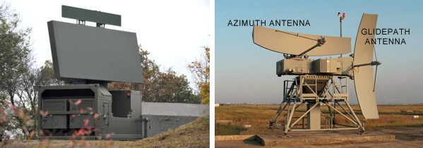
Regulatory and Regional Variations
- France: SRE and PAR are strictly military, procedures found only in MilAIP.
- United States: ASR and PAR approaches published for some joint-use airports, civil use permitted at designated locations with appropriate minima.
- UK/Commonwealth: SRA procedures provide similar controller-vectoring approaches under ICAO and national regulations.
Use Cases and Examples
- Military (e.g., Avord Air Base, France): SRE guides military arrivals to the IAF, then hands off to PAR for precision landing. Civilian use is prohibited except for emergencies.
- Civil (e.g., Nassau, Bahamas): SRE approach charts published for specific runways, controllers provide heading and range to pilots, who must acquire the runway visually to land.
- Joint-use (e.g., Key West International, US): ASR approaches available to both military and authorized civil traffic.
Operational Scenarios:
- Low-visibility or IMC operations as a primary or backup approach method.
- Training of controllers and pilots for non-precision, ground-controlled approaches.
- Contingency use when ILS or GNSS navigation aids are unavailable.
Abbreviations
| Abbreviation | Definition |
|---|---|
| SRE | Surveillance Radar Element |
| PAR | Precision Approach Radar |
| GCA | Ground-Controlled Approach |
| ASR | Airport Surveillance Radar |
| SRA | Surveillance Radar Approach |
| CAM | Circulation Aérienne Militaire (Military Air Traffic, FR) |
| CAG | Circulation Aérienne Générale (Civil Air Traffic, FR) |
| IAF | Initial Approach Fix |
| SSR | Secondary Surveillance Radar |
| PSR | Primary Surveillance Radar |
Visual Reference
Summary
The Surveillance Radar Element (SRE) is a foundational technology in military approach control, enabling safe, efficient, and resilient runway operations in all weather conditions. Its robust surveillance, vectoring, and redundancy capabilities ensure critical support for both routine and contingency airfield operations.
For more on integrating or upgrading SRE capabilities at your facility, Contact us or Schedule a Demo .
Frequently Asked Questions
- What does the Surveillance Radar Element (SRE) do?
- The SRE provides real-time radar data on aircraft position in azimuth (direction) and distance (range) to air traffic controllers. It is used to monitor and vector aircraft during the approach phase, particularly at military airfields, ensuring safe sequencing and alignment with the runway before handoff to precision approach systems.
- How does an SRE differ from a Precision Approach Radar (PAR)?
- SRE supplies only azimuth and range information, offering wide-area surveillance for initial and intermediate approach phases. PAR, by contrast, provides both lateral (azimuth) and vertical (elevation) guidance in a narrow beam for the final precision approach segment, guiding aircraft down to the runway threshold.
- Is the SRE used in civil aviation?
- SRE is primarily a military technology. In some joint-use (civil-military) airports, similar procedures may be available to civil aircraft, but pure SRE systems and procedures are usually reserved for military flights, especially in countries like France. In the US, analogous ASR and PAR approaches can be published for civil use at designated airports.
- What are the main technical features of modern SRE systems?
- Modern SREs use S-band frequencies for optimal detection and weather penetration, dual-beam electronically steered antennas, solid-state transmitters, and advanced digital signal processing for clutter suppression and moving target detection. Many support remote and unmanned operation, sector blanking, and continuous built-in test (BIT) for reliability.
- Why are SREs important in low-visibility or degraded operations?
- When visual cues are unavailable (e.g., fog, night, heavy precipitation), SREs provide controllers with accurate, real-time positional data for aircraft. This allows safe approach sequencing and runway alignment, maintaining separation and safety margins when primary navigation aids are unavailable.
- Can SREs operate unmanned or be controlled remotely?
- Yes, modern SRE installations often support remote or even unmanned operation, with monitoring and control performed from central ATC facilities via secure networks. This enables radar coverage at remote or austere airfields without full-time on-site staffing.
This is a reference entry. TarmacView provides drone inspection services and doesn't sell the equipment or materials described in this glossary.