What is HDOP (Horizontal Dilution of Precision)?
HDOP (Horizontal Dilution of Precision) – In-Depth Guide
Definition
Horizontal Dilution of Precision (HDOP) is a key metric in GNSS (Global Navigation Satellite System) and GPS (Global Positioning System) technology. HDOP numerically expresses how the spatial arrangement of satellites at the time of a position fix affects the accuracy of horizontal coordinates, specifically latitude and longitude. Lower HDOP values indicate satellites are well-distributed across the sky, which reduces the geometric amplification of errors and yields higher-confidence positions. Conversely, high HDOP values reflect poor satellite geometry (e.g., satellites closely grouped or blocked), which amplifies errors and increases uncertainty in horizontal location. HDOP is unitless and directly multiplies the expected measurement error (User Equivalent Range Error, UERE), making it a crucial real-time quality indicator for every GNSS position fix.
The Core Concept: HDOP and the DOP Family
HDOP is a member of the broader Dilution of Precision (DOP) family, which includes:
- GDOP (Geometric DOP): Overall 3D position and time accuracy.
- PDOP (Position DOP): 3D position accuracy (horizontal + vertical).
- HDOP (Horizontal DOP): Horizontal (latitude and longitude) accuracy.
- VDOP (Vertical DOP): Vertical (altitude) accuracy.
- TDOP (Time DOP): Accuracy of the receiver’s clock solution.
HDOP is most important when horizontal accuracy is mission-critical, such as in mapping, surveying, or navigation. It translates the geometric strength of satellite configuration into a single, easy-to-understand value.
Mathematical Foundation
HDOP is calculated by GNSS receivers as part of the position estimation process. It is based on the covariance matrix generated when solving for unknowns (position and time) using pseudoranges to each satellite. The relevant formula is:
[ \text{HDOP} = \sqrt{\sigma_X^2 + \sigma_Y^2} ]
Where:
- (\sigma_X) = normalized standard deviation in the east-west direction
- (\sigma_Y) = normalized standard deviation in the north-south direction
The observed horizontal error can be estimated as:
[ \text{Observed Horizontal Error} = \text{HDOP} \times \text{UERE} ]
Where UERE (User Equivalent Range Error) includes all other error sources, atmospheric delay, receiver noise, multipath, etc. HDOP quantifies how these errors are magnified or minimized by the current satellite layout.
Why HDOP Matters
HDOP is essential for:
- Surveying: Ensuring boundary and engineering measurements meet legal and technical standards.
- Mapping: Providing reliable GIS data for asset management, resource tracking, and spatial analysis.
- Precision Agriculture: Guiding autonomous machinery for planting, spraying, and harvesting with minimal overlap or gaps.
- Navigation: Supporting marine, aviation, and land navigation where positional reliability impacts safety and efficiency.
- Emergency Response: Enabling accurate dispatch and resource tracking in critical incidents.
Key Point: A low HDOP ensures that position errors remain small and reliable. High HDOP can render GNSS data unusable for precision work.
Interpreting HDOP Values
| HDOP Value | Interpretation | Application Suitability |
|---|---|---|
| 1.0 – 2.0 | Excellent geometry, high confidence | Surveying, legal mapping, precision |
| 2.1 – 5.0 | Good geometry, generally reliable | General navigation, mapping |
| 5.1 – 10.0 | Moderate/poor geometry, use with caution | Rough guidance, non-critical |
| > 10.0 | Very poor geometry, unreliable | Not suitable for precision work |
Best Practice: Set HDOP thresholds in your workflow (e.g., ≤2 for surveys) and avoid using data collected when HDOP is high.
Visualizing HDOP: Good vs Poor Satellite Geometry
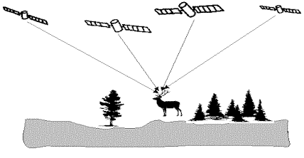
Good geometry (low HDOP): Satellites spaced widely around the sky, ensuring precise position convergence.
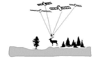
Poor geometry (high HDOP): Satellites clustered together, causing amplified error and poor position precision.
HDOP and Satellite Constellations
The number and spatial spread of satellites directly determine HDOP. Modern multi-constellation receivers (using GPS, GLONASS, Galileo, BeiDou) can see more satellites, improving geometry and lowering HDOP, especially helpful in urban areas or challenging terrain.
Ideal geometry: Satellites are evenly distributed overhead and toward the horizon in all directions.
Poor geometry: Satellites are bunched together, or many are blocked by obstructions (buildings, mountains, trees).
Mission planning tools are used to predict HDOP values for future dates and locations, helping crews schedule high-precision tasks for periods of optimal satellite geometry.
HDOP Within the DOP Family
| DOP Type | What It Measures | When Important |
|---|---|---|
| GDOP | 3D position + time | All-in-one performance |
| PDOP | 3D position (horizontal + vertical) | General position accuracy |
| HDOP | Horizontal position (lat/lon) | Mapping, surveying, navigation |
| VDOP | Vertical (altitude) | Aviation, altimetry, topography |
| TDOP | Timing accuracy | High-precision synchronization |
What Affects HDOP?
- Satellite Geometry: The more widely spaced the satellites, the lower the HDOP.
- Number of Satellites: More satellites generally mean lower HDOP.
- Obstructions: Buildings, trees, or mountains can block satellites, increasing HDOP.
- Atmospheric Conditions: Severe ionospheric or tropospheric delays can cause signal loss, reducing usable satellites and increasing HDOP.
- Multipath Effects: Reflected signals may be excluded, degrading geometry.
- Constellation Diversity: Using multiple GNSS systems increases the satellite pool and improves geometry.
Practical Usecases
Land & Engineering Surveying:
Legal and engineering-grade surveys set strict HDOP limits (often ≤2). Work is paused when HDOP is high to maintain defensible accuracy.
Precision Agriculture:
Autonomous tractors monitor HDOP in real time, pausing or correcting operations if it rises above set limits.
Marine and Offshore Operations:
Dynamic positioning systems on ships and survey vessels use HDOP alarms to maintain location reliability.
Aviation and Navigation:
Flight management and approach procedures require low HDOP for safe and accurate landing and navigation.
Emergency Response:
Dispatch systems use HDOP to filter out unreliable GNSS positions in critical situations.
HDOP in Data Quality Control
- Thresholds: Data is tagged or discarded if HDOP exceeds pre-set thresholds.
- Traceability: HDOP is logged with every position fix for post-processing quality checks.
- Industry Practices: Strict HDOP enforcement is a standard part of legal, engineering, and high-value mapping workflows.
Troubleshooting High HDOP
- Move to a more open location to see more satellites.
- Schedule work for times of optimal geometry (using mission planning tools).
- Use multi-constellation receivers to increase satellite count.
- Optimize antenna placement (away from obstructions and reflective surfaces).
- Set strict HDOP filters in software/hardware to accept only high-quality fixes.
Example Scenarios
- Surveying: Work is paused if HDOP >1.5, ensuring legal-grade position reliability.
- Agriculture: Tractors stop or slow if HDOP rises above 2.0 to avoid misplanting.
- Marine: Vessels trigger alarms if HDOP >5.0, switching to alternative navigation if needed.
- Emergency: Search crews avoid decisions based on high-HDOP data in dense urban areas.
Related Terms
- GNSS: Global Navigation Satellite System (umbrella term for all satellite navigation systems)
- GPS: US-operated GNSS
- Satellite Constellation: Satellites available for a position fix
- Multipath: Signal reflections causing GNSS errors
- Augmentation System: SBAS, RTK, and other technologies improving GNSS accuracy
- Mission Planning: Scheduling data collection for periods of low HDOP
Summary Table: HDOP Thresholds for Key Applications
| Application Area | Typical HDOP Threshold | Notes |
|---|---|---|
| Land Surveying | ≤ 2.0 | Legal, engineering, and boundary work |
| GIS/Mapping | ≤ 3.0 | General spatial data collection |
| Precision Agriculture | ≤ 2.0 | Automated equipment guidance |
| Navigation (Marine/Air) | ≤ 5.0 | Safe navigation, non-critical applications |
Final Takeaway
HDOP is the gateway to GNSS positional reliability.
By monitoring, planning for, and controlling HDOP, professionals ensure that location data meets the accuracy standards demanded by high-stakes surveying, mapping, agriculture, navigation, and emergency response. Always strive for the lowest practical HDOP to guarantee the integrity of your spatial data.
If you want to learn more about how to monitor and optimize HDOP in your workflows, contact us or schedule a demo with our GNSS experts.
Frequently Asked Questions
- What does HDOP stand for in GPS and GNSS?
- HDOP stands for Horizontal Dilution of Precision. It is a dimensionless value used in GNSS (including GPS) that describes how the spatial geometry of satellites affects the accuracy of horizontal position estimates (latitude and longitude). Lower HDOP values indicate better geometry and higher confidence in position accuracy.
- How is HDOP calculated?
- HDOP is computed by GNSS receivers using the covariance matrix of the satellite geometry during the position calculation process. It is derived from the standard deviations in the east-west (X) and north-south (Y) components, combined as: HDOP = sqrt(σX² + σY²), where σX and σY are the normalized uncertainties in those directions.
- What is a good HDOP value for surveying?
- For legal, cadastral, or engineering surveys, an HDOP of ≤2.0 is typically required. This ensures high positional reliability for boundary marking, construction, and mapping. General mapping or GIS work may accept HDOP up to 3.0, but higher values reduce accuracy and confidence.
- What causes high HDOP values?
- High HDOP is mainly caused by poor satellite geometry, when satellites are clustered together or blocked by obstructions like buildings or trees. Fewer satellites in view, or satellites being close to the horizon, can also increase HDOP. Multi-constellation receivers and good antenna placement help minimize HDOP.
- How does HDOP affect GNSS position accuracy?
- HDOP acts as a multiplier on all other sources of GNSS error (like atmospheric effects). The larger the HDOP, the greater the uncertainty in the horizontal position. For example, if the User Equivalent Range Error is 1.5 meters and HDOP is 2.0, the expected horizontal error is 3 meters.
- How can I reduce or control HDOP during GNSS data collection?
- You can reduce HDOP by using multi-constellation receivers (to access more satellites), planning fieldwork for times of optimal satellite geometry, placing the antenna in open areas clear of obstructions, and using real-time HDOP monitoring to pause data collection when HDOP exceeds set thresholds.
This is a reference entry. TarmacView provides drone inspection services and doesn't sell the equipment or materials described in this glossary.