PAPI Protection Surface Check After Works or Growth
How an aerodrome shows its PAPI approach is unobstructed after works or tree growth. TarmacView's own check is in active development and not offered yet.
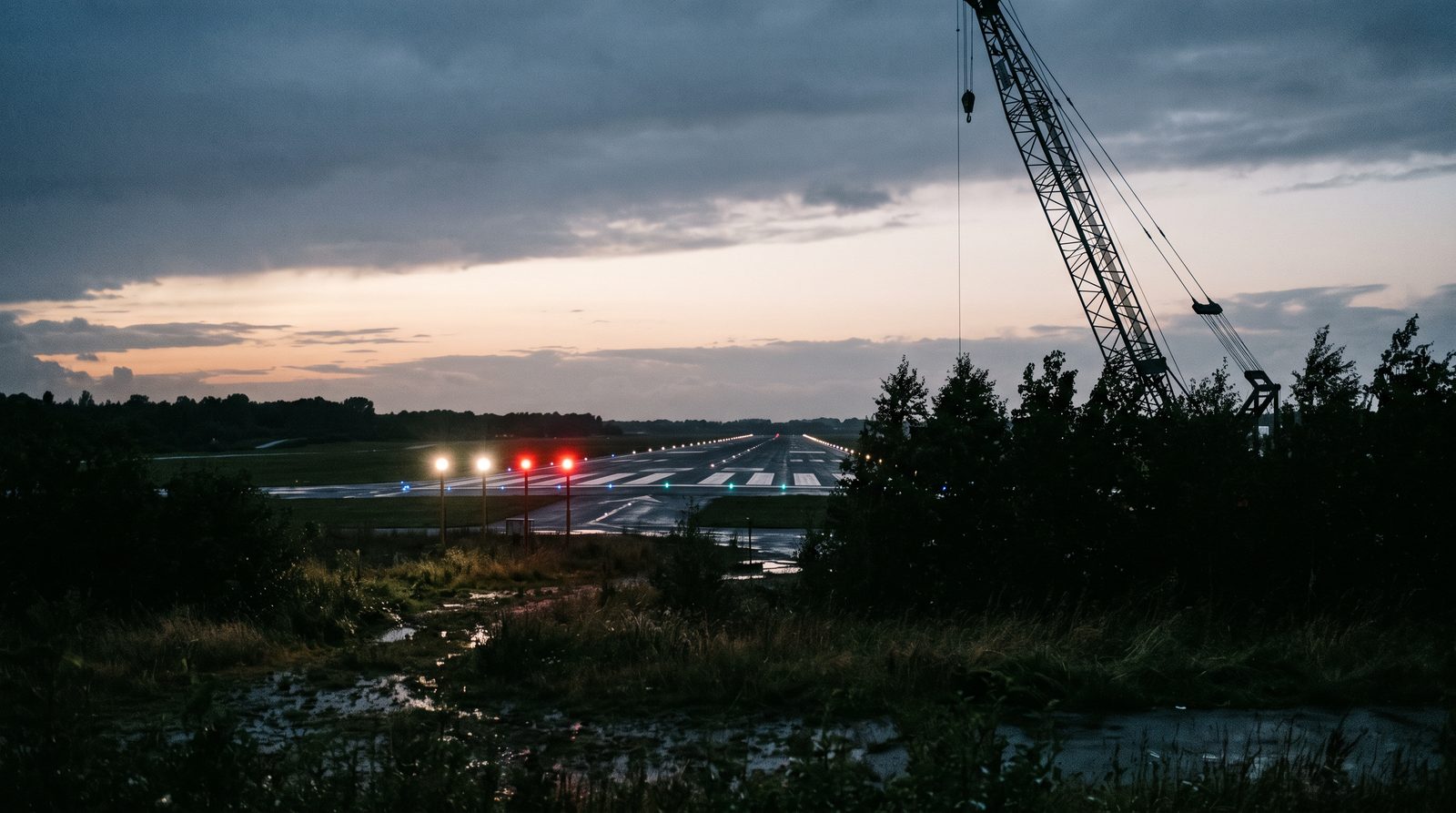
- 01 The protection surface is defined by the standards from the PAPI's own geometry, so the check is a computation against a known plane, not an opinion about the view.
- 02 Most penetrations are not buildings but growth, and growth does not appear in any obstacle register until someone looks.
- 03 The surveyed obstacle set is tested first. The flight exists to find what the set does not contain.
- 04 A penetration needs a position and a height before a tree owner, a contractor or an authority can act. TarmacView's register holds heights as entered, not measured from imagery.
- 05 A resurfacing that moved the threshold or the PAPI moves the surface too, so the check belongs in the works handover, not a year later.
Who runs into this
Nobody wakes up wanting a protection surface check. Something changes near the approach and the question arrives with it.
- The runway was resurfaced, the threshold moved by a few metres, and the works handover asks whether the approach is still clear for the re-aimed PAPI.
- A planning application, a crane notification or a new roofline appears in the safeguarding inbox, and the officer has a drawing to test it against and no current survey.
- A pilot reports trees in the approach. The last obstacle survey is from certification, and the trees were shorter then.
- An audit asks for the record behind the statement that the approach is unobstructed, and the record turns out to be the certification survey.
What these have in common is a surface nobody can see. A PAPI is a piece of equipment. Its obstacle protection surface is a plane in the air defined by the equipment’s position and angle, and the only question that matters is whether anything crosses it.
Where this applies, and where it does not
This applies to any runway with a visual approach slope indicator, from a single PAPI at a grass aerodrome to both ends of a precision runway, because the surface is defined the same way everywhere and only its dimensions change with the runway code. It applies whenever the geometry moved or the surroundings did.
What TarmacView offers for this today is narrower than the full check. Obstacles in the register, with their MSL and ellipsoid heights, are tested against the Annex 14 approach surface and a penetration shows as a warning in flight planning. The register exports on the airport data sheet as JSON, CSV or PDF. A check against the PAPI’s own protection surface, with a flown sightline, is in development.
It does not cover the wider set of surfaces around the aerodrome, the approach, transitional, inner horizontal and conical surfaces. That is the obstacle limitation surface survey , and the PAPI-side check is part of the same development. It does not verify the PAPI’s own angles and colour, which is the PAPI inspection . And it is not the obstacle assessment for an instrument approach procedure, which tests against procedure surfaces rather than the aerodrome’s.
What has to be true before the approach can be called clear
- Surface constructed
- The plane is built from the PAPI position, its set angle and the Annex 14 dimensions for the runway, or from your published values.
- Register tested
- Every surveyed obstacle is tested against the plane as a computation, before any flight.
- Sightline flown
- The surface is flown as an arc with the camera on the plane, so unsurveyed objects are seen rather than assumed absent.
- Penetrations measured
- Any object crossing the plane needs a surveyed position and a top height with stated uncertainty. TarmacView does not measure these from imagery today, so a ground survey supplies them.
- What TarmacView does today
- It warns in flight planning when a registered obstacle penetrates the Annex 14 approach surface. The PAPI protection surface check and the flown sightline are in development.
- Margins stated
- Objects close to the plane are reported as marginal with the distance, not rounded into a pass.
- Evidence retained
- The flight record and positioning log are kept, so a disputed object can be re-examined without a new flight.
- Decision left open
- Whether a penetration is acceptable is the operator's and the authority's. The check supplies the facts.
What the aerodrome is trying to achieve
A signed-off approach after works
The handover of a resurfacing or a PAPI relocation needs a statement that the approach is clear against the new geometry. A check done at handover, with the plane built from the as-built positions, is that statement.
A defensible answer to an application
A safeguarding officer who tests a crane or a roofline against a constructed plane, with the surveyed obstacle set beside it, can answer in writing and show the working. One who tests it against a drawing from certification cannot.
A trend on the trees
Growth is the penetration nobody notifies. A check repeated each winter against the same plane turns tree height into a series, and a series says when to cut rather than whether.
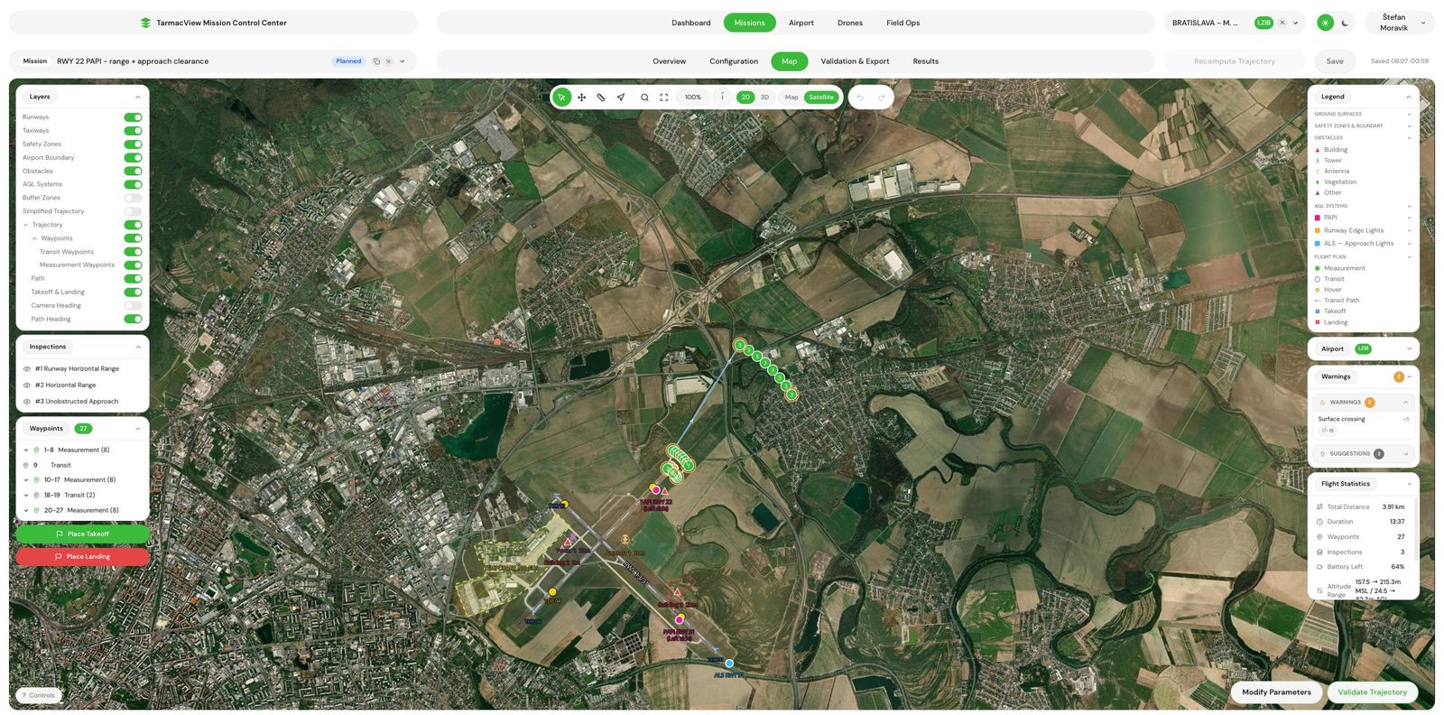
The arc flown on the protection surface plane, aimed at a point on the extended centreline. Anything crossing the plane passes in front of the camera.
How the check runs
Five steps, most of them before anyone flies. The flight is the shortest part.
From geometry to a clear approach
- 01
Fix the geometry the surface is built from
Take the PAPI position and set angle from the handover survey or the last inspection report, the threshold coordinates from the aerodrome data, and the surface dimensions from Annex 14 or your published values for the runway code. Record the source of each.
WhyThe plane depends on the PAPI's surveyed position, its set angle and the runway's threshold position. After works, the as-built values are the only ones that count.
Done whenEvery parameter of the plane has a value and a source, and the operator has signed the set off.
If notIf the PAPI position or angle is not on record, the check begins with a PAPI inspection that measures them.
- 02
Test the obstacle register against the plane
Test every surveyed object's position and top height against the constructed plane. List penetrations and every object within a margin of the plane as candidates for the flight.
WhyThe register holds what was surveyed. Testing it is arithmetic, and it sorts objects into clear, marginal and penetrating before the visit.
Done whenA candidate list exists, and the objects on it are on the flight plan.
If notIf there is no register, or it predates the last works, the flight covers the whole surface and the check produces the register.
- 03
Fly the surface
Between aircraft movements and in coordination with the tower, fly the arc at the height the plane reaches at each radius, sweeping the sector either side of the runway axis, with the camera on a point on the plane.
WhyThe plane is a physical thing only from the air. An arc flown on it with the camera locked on the plane shows exactly what crosses it, including what no register contains.
Done whenThe full sector is recorded with a positioning fix on every frame, and every candidate from the register was in view.
If notFog, low sun into the camera or wind above the limit stop the flight. The pass is repeated rather than rated through the conditions.
- 04
Measure what crosses
For each object seen crossing or near the plane, measure its position and top height with a ground survey or RTK positioning and state the uncertainty. Report how far above or below the plane the top sits.
WhyA penetration has to be a number, not an impression, before anyone can cut a tree or lower a crane.
Done whenEvery penetration and every marginal object has a position, a height with uncertainty, and a margin in metres.
If notAn object whose margin is inside the uncertainty is reported as marginal, with the ground survey that would settle it named.
- 05
Hand over the record
Deliver the surface parameters, the register test, the flight record, the penetration list with evidence, and a plain statement of what is clear, marginal and penetrating.
WhyThe check exists for the record: the handover file, the safeguarding decision, the audit.
Done whenThe record can be handed to the authority, the contractor or the landowner without a covering explanation.
If notA disputed object is re-examined against the retained frames. Only inadequate data leads to a new flight.
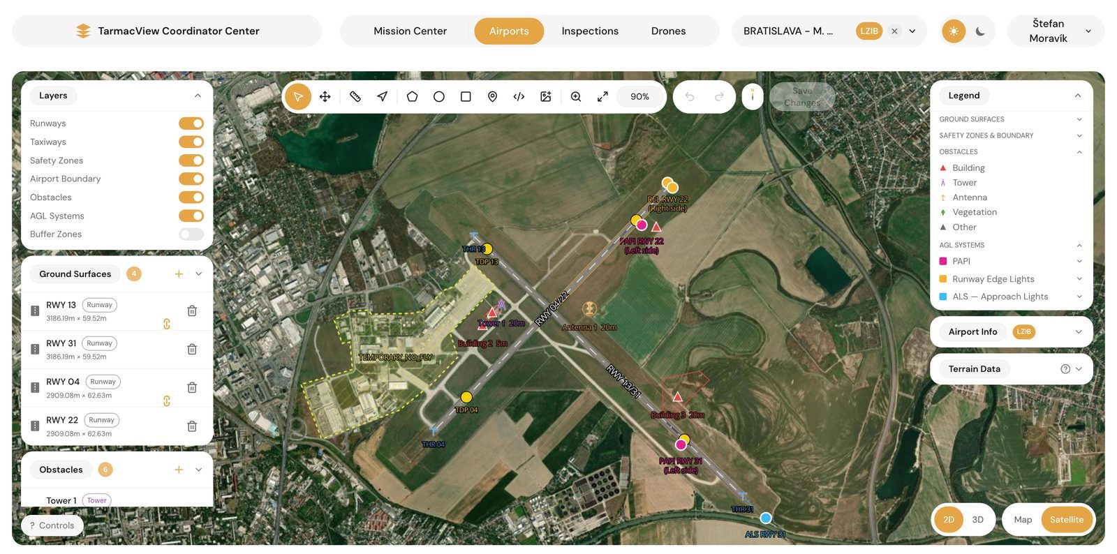
The register test comes first. Every surveyed object is sorted into clear, marginal and penetrating before the aircraft leaves the ground.
Four ways to answer whether the approach is clear
| Method | What it does | Evidence it leaves | Where it stops |
|---|---|---|---|
| Drive out and look | A person judges the approach from the ground by eye | A note, sometimes a photograph | Cannot place a plane in the air or measure a height, and misses growth until it is obvious |
| Pilot report | A crew notices something on the approach and reports it | A report, after the fact | Arrives late, unmeasured, and only for what the crew happened to see |
| Ground survey of the register | A surveyor measures the known obstacles and tests them against the surface | Certified positions and heights for the surveyed set | Only the surveyed set, a day per aerodrome, and nothing about objects not on the list |
| Drone check on the plane | Builds the plane, tests the register and flies the arc. Today only the approach surface test exists, as a flight-planning warning | A flight-planning warning and a register entry today | Certified data for publication, measured heights and the decision on what to do with a penetration |
Governance and the record
The statement that an approach is clear is one an authority will ask to see the basis for, and one a landowner may contest. The record has to be reconstructable: the surface parameters and their sources, the register that was tested, the flight with its positioning log, and the measurement of each penetration with its uncertainty. A statement of “clear” with nothing behind it is what the certification survey already provided, and its age is why the question came up.
Evidence and the honest limits
The strong part is geometry. The plane is defined by numbers the aerodrome already holds, positions are RTK-referenced, and an angle between two known points is a computation with a bound on it. Whether an object of known height at a known position crosses a known plane is arithmetic.
The weaker part is the top of a tree. A mast or a roofline has an edge. A crown does not, it moves in wind, and it is taller in August than in February. A check therefore has to state a height with an uncertainty and treat objects inside that uncertainty as marginal, with a ground survey to settle them. It also has to record the date, because a tree measured in winter is a lower bound on the summer. TarmacView does not measure heights from imagery today.
The check does not produce certified obstacle data for publication, which needs a licensed surveyor and a formal data chain, and it does not assess an instrument procedure. A full check answers one question completely: is anything in this PAPI’s protection surface today, and if so, where and how far. Today TarmacView answers a narrower one, whether a registered obstacle penetrates the approach surface.
Objections worth raising
“Our register is current.” Then the register test will pass quickly and a flight would find nothing, which is the cheapest outcome and still a record with a date on it. The flight exists for the objects the register does not contain.
“The contractor certified the works.” The contractor certified the pavement and probably re-aimed the PAPI. Ask whether anyone rebuilt the protection surface from the as-built geometry and tested the surroundings against it. Usually nobody did, because it is not part of the works.
“We can see the approach from the tower.” The tower sees the approach from the wrong height and the wrong place. The plane is a few degrees above the ground and a few hundred metres out. What looks like a hedge from the tower can be a penetration at the surface.
“The trees are on someone else’s land.” They usually are, and that is why the record matters. A measured penetration with frames behind it is what turns a request to cut into an obligation.
Related tasks
If the question is the whole set of surfaces around the aerodrome, the obstacle limitation surface survey is the page. If it is whether the PAPI itself is still on angle after the works, the PAPI inspection answers that. If it is what a drone measurement is worth as evidence, how a drone measurement becomes evidence sets out the chain.
Frequently Asked Questions
- What exactly is the PAPI obstacle protection surface?
- A plane that the standards define for every visual approach slope indicator. It starts a short distance in front of the threshold at a set width, diverges outward on both sides at a fixed rate, and climbs along the approach at an angle slightly below the glide path the PAPI is set to. Its purpose is to guarantee that an aircraft following the on-slope signal has nothing in its way. ICAO Annex 14 gives the dimensions and slopes by runway type. European certified aerodromes read the same numbers in CS-ADR-DSN. Because it is built from the PAPI's position and set angle, it can be constructed exactly, and anything above it is by definition a penetration.
- Why does a resurfacing trigger a check?
- Because the surface is anchored to the runway. A resurfacing that lifts the pavement, moves the threshold or relocates the PAPI moves the plane with it, and an object that cleared the old plane may not clear the new one. The PAPI itself is usually re-aimed at handover and the angles verified. The protection surface is the part that gets forgotten, because it is not a piece of equipment. Putting the check into the works acceptance closes that gap at the moment the geometry is known.
- Trees grow slowly. How often should the surface be checked?
- Often enough that a penetration is caught before an inspector or a pilot report catches it. A poplar can add a metre a year, and a line of them at the edge of the approach can cross a surface that slopes at a few degrees within a couple of seasons. Aerodromes with woodland under the approach tend to check annually, in winter when the canopy is at its lowest height and the summer growth is known. Aerodromes with cleared surroundings check when something changes: a permit, a crane, a works handover.
- We have an obstacle register. Is that not enough?
- It is the first half. The register tells you what was surveyed on the day it was surveyed, and the check tests every object in it against the surface as a computation, before anyone flies. What the register cannot do is contain objects nobody surveyed: the tree that grew, the mast that was not notified, the temporary crane. The flight along the surface is what finds those. Both halves together are the check. The register alone is a statement about the past.
- What does a flight along the surface show?
- The aircraft flies an arc that lies on the protection surface plane, at the height the plane reaches at that distance, with the camera locked on a point that also lies on the plane. That turns the recorded view into a physical sample of the surface: anything penetrating it passes in front of the camera. Today TarmacView does not fly this check for obstacles or measure top heights from imagery. A penetration stated in metres, with an uncertainty, needs a ground survey of the object.
- What do we get if something penetrates?
- Today, a warning in flight planning that the obstacle penetrates the Annex 14 approach surface, which is a different surface from the PAPI protection surface, and the obstacle's entry in the register with its polygon, type and heights. It is not a report with a measured top height. A landowner who must agree a cut, or a contractor who must lower a crane, needs a measured height, and TarmacView does not measure heights from imagery today. A ground survey of the object supplies it. What you do not get is the decision about whether the PAPI can stay in service in the meantime. That is the operator's and the authority's, and it usually depends on how far the penetration is from the on-slope signal.
References
- icao-annex-14-v1
- Annex 14 to the Convention on International Civil Aviation, Volume I: Aerodrome Design and Operations International Civil Aviation Organization
- icao-doc-9157-p4
- Doc 9157, Aerodrome Design Manual, Part 4: Visual Aids International Civil Aviation Organization
- easa-cs-adr-dsn-7
- Certification Specifications and Guidance Material for Aerodrome Design, CS-ADR-DSN Issue 7 European Union Aviation Safety Agency