NATO and Allied Airfield Pavement Condition by Drone
One drone PCI survey for every allied airfield, following the STANAG 7181 and AEP-56 method. Every sample unit rated, the runway reopens when the drone lands.
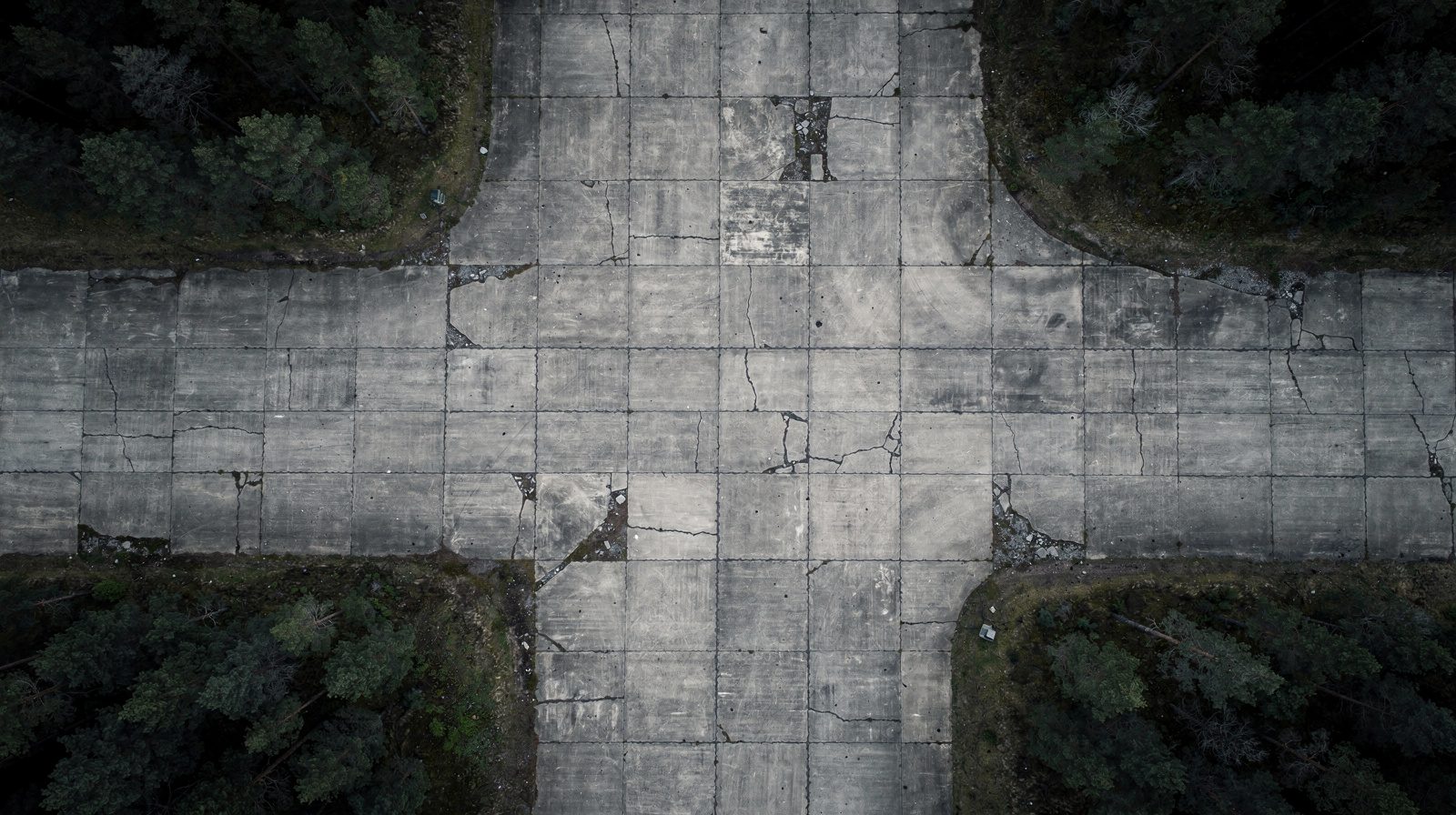
- 01 The drone images every square metre at 1 to 5 mm per pixel and rates every sample unit by the D5340 definitions, so the PCI comes from the whole surface and not from a sample.
- 02 The same software rates every airfield the same way whoever flies, so the results of different nations can be set side by side.
- 03 Runway time is the flight itself. One aircraft covers 1 km of a 45 m wide runway in 4 to 45 minutes depending on the crack size wanted, and the runway reopens as soon as the drone lands.
- 04 The survey runs on a laptop on site with no cloud, so the data stays with the nation that owns the airfield.
- 05 It follows the same PCI method and is not NATO approved. A walked survey by a certified inspector stays the record wherever a requirement names one.
On this page · 10 sections
Who runs into this
Allied nations agreed the method long ago. STANAG 7181 , published as AEP-56, is the NATO standard method for airfield Pavement Condition Index surveys. UFM 3-260-16 points to it for NATO operations. On paper there is one way to rate an allied runway.
In practice each nation walks its own sample units on its own cycle. The result is a picture of the allied network that is incomplete, because only a sample of each pavement was rated, and not comparable, because the cycles, the raters and the sampling differ. A walked survey also closes the runway while the raters work, and it needs trained raters on site, which is hard to arrange at a deployed or dispersed operating location.
It shows up in four questions.
- Can every sample unit of a main operating base be rated, and not only the units a sampling rule picked?
- Can two nations’ airfields be compared, knowing that the same rule set rated both?
- How long does the survey close the runway, and how few people need to be on the pavement?
- Where does the data go, and can it stay with the nation that owns the airfield?
The pavement condition assessment is the service behind this page. It is in development and offered as early access. This page sets out what the software does today, what it does not do, and where it is going.
Where this applies, and where it does not
This applies to paved runways, taxiways and aprons of asphalt or jointed concrete, at main operating bases, at deployed and dispersed operating locations, and at civil airports in host-nation use. It works the same on a familiar airfield and on one the team has never seen, on any asphalt or concrete surface not covered by snow, sand or water.
It follows the same PCI method as STANAG 7181 and the ASTM D5340 definitions. It sees nothing below the surface, so it gives no structural capacity and no friction. And it is not a substitute where a requirement names a walked survey signed by a certified inspector, until a side-by-side comparison with such an inspector exists.
What the survey does today
- Method
- The same PCI method as STANAG 7181 and AEP-56, with the distress definitions of ASTM D5340 and the catalogue transcribed from UFM 3-260-16.
- Coverage
- Every square metre imaged at 1 to 5 mm per pixel. Every distress found, measured and rated, and the PCI computed for every sample unit, not a sample.
- Runway time
- 4 min per km of a 45 m wide runway for cracks from 10 mm, 13 min from 5 mm, 45 min for the full survey at 1 mm per pixel. One aircraft, launched from the shoulder.
- Time to report
- About 20 minutes from image capture to PCI report for 1 km of runway at 5 mm per pixel.
- Where it runs
- A MacBook or a PC with a graphics card, on site. No cloud needed.
- Output
- A GeoJSON inventory any national GIS opens, PCI per sample unit and section, a PDF condition sheet per unit, CSV tables.
- Aircraft
- DJI, MAVLink (PX4 and ArduPilot) and UgCS. Partner operators fly Blue UAS cleared aircraft.
- Supplier
- TarmacView j. s. a., Bratislava, NATO NCAGE code 0181M.
Every sample unit rated, one rule set
The drone images the pavement at 1 to 5 mm per pixel. The software then finds, measures and rates every distress by the D5340 definitions and computes the PCI of every sample unit and of each section. Cracks are rated automatically with a severity taken from the measured width. On asphalt that covers alligator, block, longitudinal and transverse cracking. On concrete it covers linear cracking and joint and corner spalling. A classifier labels each tile with the other D5340 types and already recognises all 33 of them, and the report lists which types were rated and which were not, because an unrated type biases the PCI upward.
The ratings are the same whoever flies the survey. A national team, a host-nation team or a partner operator gives the same pavement the same figure, because the figure comes from the imagery and one rule set and not from the judgement of the rater of the day. That is what lets two nations compare their airfields.
Checked against the worked examples in UFM 3-260-16, the PCI of both the asphalt and the concrete example lands within 1 point. A section surveyed again on the same runway repeats within 1 point.
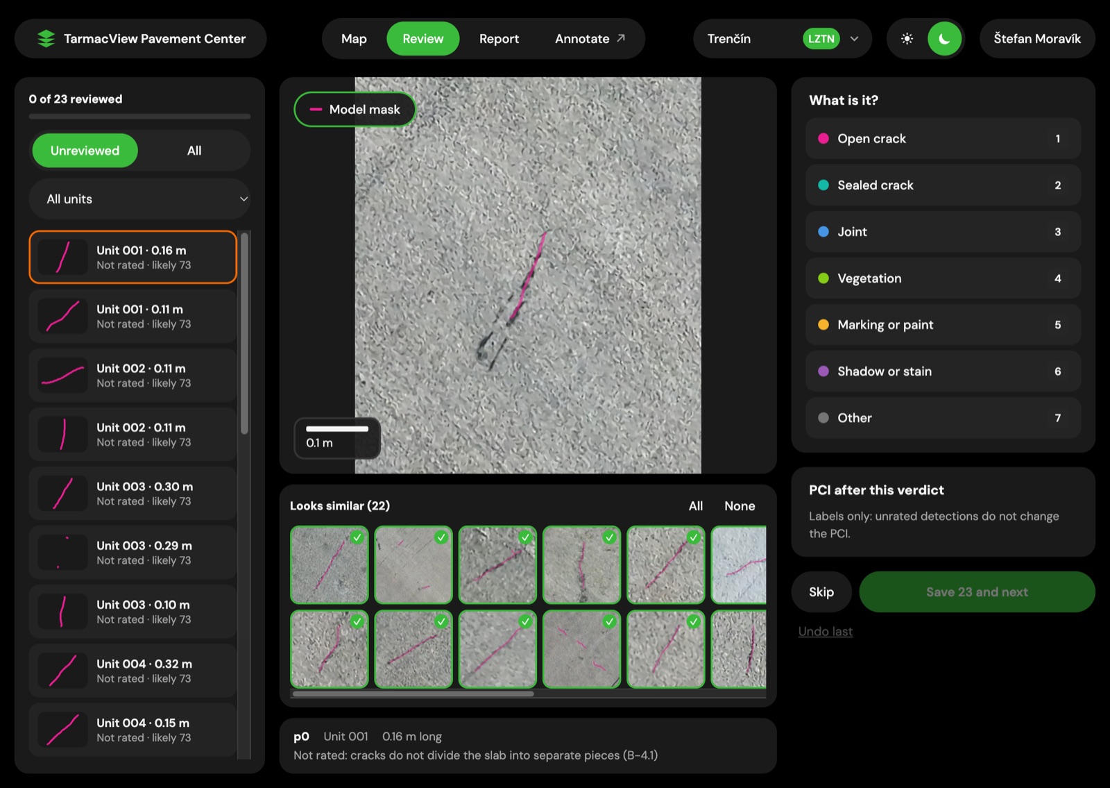
Review on a concrete runway at 1 mm per pixel. The analyst sees a hairline crack next to the 22 detections that look like it and marks them in one save.
Minutes of runway time, not a closure
Capture is the only step on the airfield. For 1 km of a 45 m wide runway, one aircraft needs 4 minutes to find cracks from 10 mm, 13 minutes to find cracks from 5 mm and 45 minutes for the full survey at 1 mm per pixel, with cracks from 2 mm. More aircraft cut these times. The aircraft launches from the shoulder and nothing touches the pavement, so the runway reopens as soon as the drone lands. A walked survey keeps the runway closed for as long as the raters walk it.
Processing on site, data with the nation
About 20 minutes pass from the end of capture to the PCI report for 1 km of runway at 5 mm per pixel. On a MacBook processing takes about 30 minutes per 100 m of runway at 1 mm per pixel and about 2 minutes at 5 mm. The software runs on a MacBook or on a PC with a graphics card, on site, and needs no cloud. Imagery and results stay on the machine the nation provides. The orthomosaic is built from the drone positions, 6 times faster than photogrammetry, with a PCI within 1 point of the photogrammetric result.
Analyst review
The report never waits for review. Each detection is shown next to the cracks that look like it, and the analyst marks a sealed crack, joint, vegetation, paint or stain in one save and sees the PCI of the unit change at once. Sealant and paint edges read as cracks, and clearing them takes minutes. Every verdict becomes a training label for the next version of the models.
What a national GIS receives
Every distress keeps its map position, its length in metres and its width in millimetres, and on concrete the distress sits on the slab grid. A repeat survey therefore shows how each crack grows. The inventory is a GeoJSON file, so any national GIS opens it. The PDF condition sheet for each sample unit shows the deduct calculation line by line, which is the document an engineer checks the PCI against.
Why walked surveys do not add up across nations
A walked survey rates the units a sampling rule selected and infers the section from them. That is a sound statistical method, and it is the reason a PCI of a large pavement was practical to walk at all. The weakness is in what happens around it. The cycle differs from nation to nation. The raters differ. The units picked differ. When two PCI values from two airfields are put in one table, the table hides all of this.
Rating every sample unit removes the sampling error from the capture. Using one rule set removes the difference between raters. What remains is the pavement itself, and that is the quantity a network planner wants to compare.
A walked AEP-56 survey and a drone PCI survey
| Question | Walked AEP-56 survey | Drone PCI survey |
|---|---|---|
| Coverage | The sample units chosen by the sampling rules, the rest inferred | Every square metre imaged, every sample unit rated |
| Rater dependence | Trained raters on site, and the result carries their judgement | One rule set, the same rating whoever flies |
| Runway time | The runway is closed while the raters walk the units | Minutes of flight per kilometre, and the runway reopens when the drone lands |
| People on the airfield | Trained raters on the pavement | A flight crew on the shoulder |
| Comparable across nations | Same method on paper, different cycles, units and raters in practice | Same method and rule set, so airfields can be set side by side |
| Data | Field sheets, entered into the pavement management system afterwards | GeoJSON, CSV and a PDF per unit, produced on site |
| Formal record | The survey a requirement naming a walked, signed PCI asks for | Follows the same PCI method and does not replace a signed walked survey where one is required |
Operating from a host-nation airfield
An allied survey often happens on ground that belongs to someone else. The data rules are those of the owning nation, the airspace belongs to its air traffic control, and the operator may have to be a vetted one.
TarmacView j. s. a., Bratislava, holds NATO NCAGE code 0181M, the identifier defence buyers use to find a supplier. Our partner operators keep a fleet of Blue UAS cleared aircraft, the aircraft the US Department of Defense vets for cybersecurity and supply-chain requirements. TarmacView itself is not on that list. The mission planner is drone agnostic, so a nation that flies its own aircraft, DJI, MAVLink on PX4 or ArduPilot, or UgCS, uses the same planner and the same processing. The data stays with the nation because the processing runs on its own laptop.
From scoping to the PCI report handed over on site
- 01
Scope the airfield and the section map
Agree the runways, taxiways and aprons in scope. Start from the nation's existing network, branch and section map where one exists and keep its identifiers.
WhyA PCI is a figure about a defined area, so the sections and sample units have to be fixed before anything is flown.
Done whenA signed section map that this survey and every later one will reuse.
If notWhere no map exists, divide by construction history and use, and record the rule.
- 02
Agree the data rules and the operator
Agree that processing runs on the nation's laptop on site, who reviews the output, and whether a national operator or a partner operator with Blue UAS cleared aircraft flies.
WhyThe host nation decides where imagery and results may be kept and who may fly.
Done whenA scope note naming the machine, the reviewer and the operator.
If notIf the rules are unclear, keep everything on the machine on site until they are agreed.
- 03
Coordinate the airspace and the runway window
Agree with air traffic control and airfield management a window sized from the chosen resolution. Plan the launch point on the shoulder, off the pavement.
WhyThe only time the survey takes from operations is the flight.
Done whenA written window of minutes per kilometre, and a launch point clear of the surface.
If notIf the window shrinks, fly at a coarser resolution or add aircraft and keep the section map unchanged.
- 04
Fly the surfaces
Plan the mission in the planner for the aircraft in use and fly the full width of each surface in daylight, on a dry surface where possible, inside the aircraft maker's wind, temperature and rain limits.
WhyEvery square metre has to be imaged for every sample unit to be rated.
Done whenEvery surface covered with a position on every frame, and the runway reopened as soon as the aircraft lands.
If notSnow, sand or water on a section means that pass is reflown once the surface is clear.
- 05
Process on site and review
Process the imagery on the laptop, read the PCI per sample unit, and clear sealant and paint edges in review. The report is available before review.
WhyThe nation keeps the data, and the report should not wait for a connection.
Done whenA PCI per sample unit and section, with the list of distress types rated and not rated.
If notA disputed detection is checked against the retained frames, not flown again.
- 06
Hand over the PCI report on site
Hand over the GeoJSON inventory, the CSV tables and the PDF condition sheet per sample unit with its deduct calculation.
WhyThe people who own the pavement should leave with the record.
Done whenThe nation holds the inventory, the report and the imagery, and can load the GeoJSON into its own GIS.
If notWhere the nation wants a walked check, pick a few sections and walk them in the same season.
Where it is going
Everything above runs on our own flights today. The direction, with no dates, is this. Every distress type rated automatically with severity. Debris flagged in the same pass. Results loading into PAVER and into GIS. Crack growth forecasts. Crack depth from angled photos. Drone docks at the base. Processing on the customer’s own secure cloud.
For a damaged airfield the direction is crater and spall depth and volume, measured from the drone imagery, to support a rapid damage assessment after an attack. This is a direction and not a feature. Airfield damage repair has its own NATO standard, STANAG 2929 and AATMP-03, and a damage assessment would feed that process. Today’s survey stops before that process.
Evidence and the honest limits
The strong claims can be checked in a pilot. Every sample unit is rated. The runway time is the flight. The PCI lands within 1 point of the UFM 3-260-16 worked examples, and the processing runs on a laptop with no connection. The PCI explainer sets out how a PCI is built, and the ASTM D5340 standard page sets out what the method requires.
Then the limits. Wind, temperature and rain limits are the aircraft maker’s. Flying is by daylight and preferably over a dry surface. Sealant and paint edges read as cracks and are cleared in review in minutes. The survey sees nothing below the surface, so it gives no structural capacity and no friction. And no certified PCI inspector has yet rated our sections side by side with the software. The way to test it on an allied airfield is to walk a few sections in the same season as a drone survey and compare unit by unit.
Objections worth raising before a pilot
“The standard is the walked survey.” Keep it where a requirement names it. The drone survey rates the whole surface in minutes of runway time and gives the walked team a map of where to look.
“Our data cannot leave the base.” It does not. Processing runs on a laptop on site with no cloud, and the files stay on the nation’s machine.
“We cannot accept a supplier we do not know.” TarmacView j. s. a. holds NATO NCAGE code 0181M, and the aircraft are operated by partners that keep a fleet of Blue UAS cleared aircraft. Neither is a NATO endorsement.
“Will two nations’ figures really compare?” The same rule set rates both, and the comparison is checkable on a few sections against walked ratings.
Related tasks
If the buyer is a national airport or road authority, government airport pavement condition takes that angle. If the question is the US military installation and UFM 3-260-16, US military airfield pavement PCI covers it. The service itself is described on the pavement condition assessment page. To talk about early access on your own sections, contact TarmacView .
Frequently Asked Questions
- Is the survey compliant with STANAG 7181 or AEP-56?
- TarmacView does not claim compliance and holds no NATO approval or endorsement. STANAG 7181 and AEP-56 describe a visual PCI method, and the survey follows the same PCI method with the distress definitions of ASTM D5340. The catalogue in the software is transcribed from UFM 3-260-16, which points to STANAG 7181 for NATO operations. Whether a given nation accepts a drone survey as its record is that nation's decision.
- How many sample units are rated?
- All of them. A walked survey rates the sample units chosen by its sampling rules and infers the rest. The drone images every square metre at 1 to 5 mm per pixel, the software finds, measures and rates every distress and computes the PCI of every sample unit and of the section. Nothing is extrapolated from a subset, and the report lists which distress types were rated and which were not.
- How long is the runway closed?
- For the length of the flight. With one aircraft, 1 km of a 45 m wide runway takes about 4 minutes for cracks from 10 mm, about 13 minutes from 5 mm and about 45 minutes for the full survey at 1 mm per pixel with cracks from 2 mm. More aircraft cut these times. The aircraft launches from the shoulder, nothing touches the pavement, and the runway reopens as soon as the drone lands.
- Does imagery or any result leave the airfield?
- Not unless the nation decides so. Processing runs on a MacBook or a PC with a graphics card on site, with no cloud needed. About 20 minutes pass from image capture to PCI report for 1 km of runway at 5 mm per pixel. The results are a GeoJSON inventory, CSV tables and a PDF per sample unit, files that stay on the national machine.
- Who flies, and with which aircraft?
- The mission planner is drone agnostic and works with DJI, with MAVLink aircraft on PX4 and ArduPilot, and with UgCS. For defence work, TarmacView j. s. a. in Bratislava holds NATO NCAGE code 0181M, and our partner operators keep a fleet of Blue UAS cleared aircraft. TarmacView itself is not on the Blue UAS list. Where a nation needs its own operator, the same software processes that operator's imagery.
- Can it assess a damaged airfield after an attack?
- Not today. The survey rates the surface condition of an intact pavement. Crater and spall depth and volume are a direction of development and have no date. STANAG 2929 and AATMP-03 on airfield damage repair set the context that such damage assessment would feed. Today's survey stops before that process.
- Does it replace the walked survey of a certified inspector?
- Not where a requirement names a walked survey signed by a certified inspector. A certified PCI inspector has not yet rated our sections side by side with the software, and until that comparison exists the walked survey is the record. The drone survey gives a complete and repeatable picture of the whole surface in minutes of runway time, and it can be checked against a walked survey section by section.
References
- stanag-7181-aep-56
- STANAG 7181 Edition 1 / AEP-56, NATO Standard Method for Airfield Pavement Condition Index (PCI) Surveys NATO Standardization Office, published on the US Tri-Service Transportation site
- ufm-3-260-16
- UFM 3-260-16, Condition Surveys of Operating Surfaces US Department of Defense, Unified Facilities Manual
- astm-d5340-24
- ASTM D5340-24, Standard Test Method for Airport Pavement Condition Index Surveys ASTM International
- blue-uas-dcma
- DIU's Blue UAS List to transition to DCMA Defense Innovation Unit
- stanag-2929
- STANAG 2929 / AATMP-03, Airfield Damage Repair (ADR) Capability NATO Standardization Office