US Military Airfield Pavement PCI Surveys by Drone
A PCI for every sample unit of a US military airfield, from drone imagery and the D5340 definitions. Early access, in development, with the limits stated.
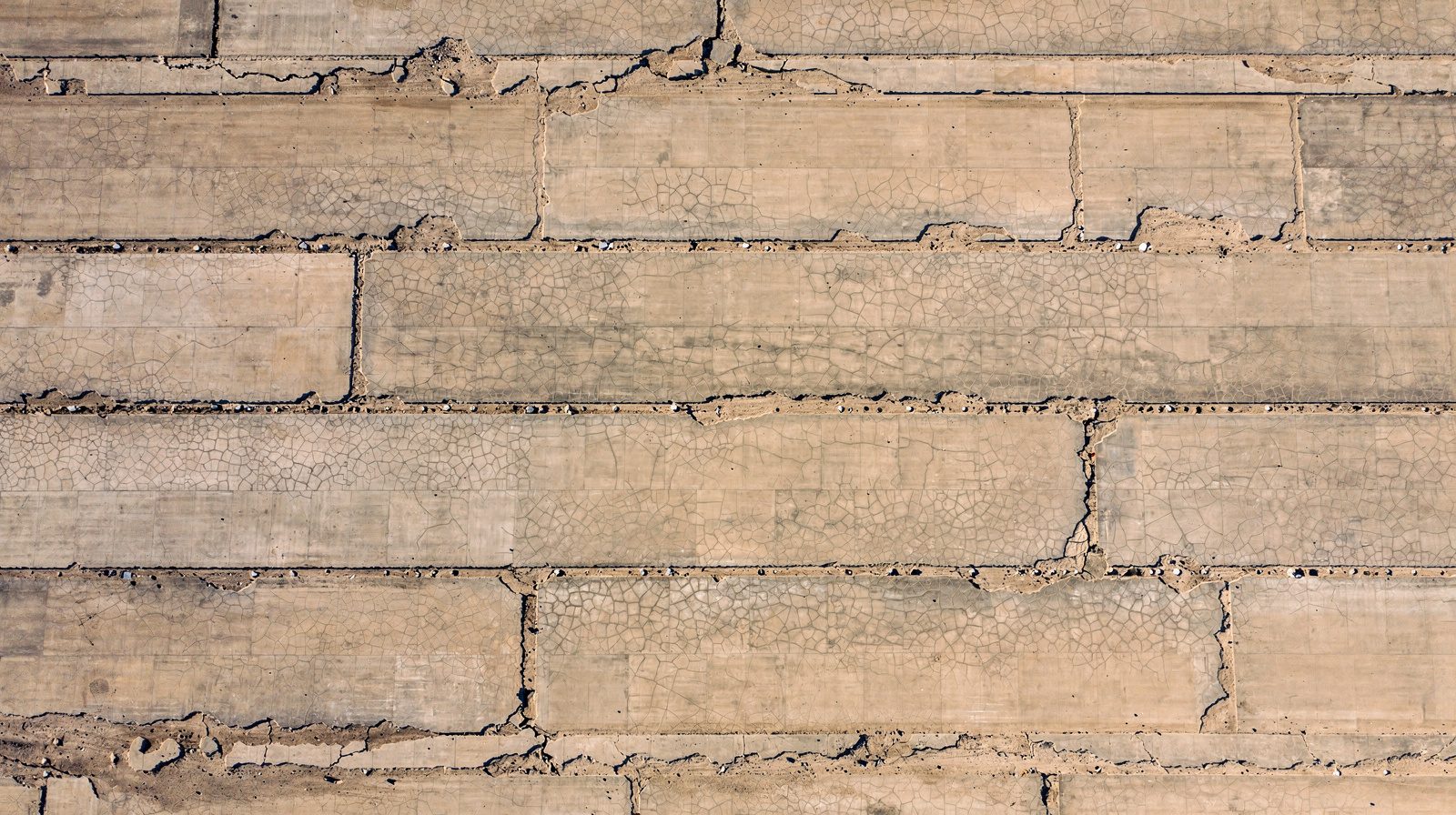
- 01 Every sample unit is rated, not a sample. The software finds, measures and rates each distress by the D5340 definitions, so the rating is the same whoever runs the survey.
- 02 PCI came within 1 point of the UFM 3-260-16 worked examples on asphalt and concrete, and a section surveyed again on the same runway repeated within 1 point.
- 03 Runway time is the flight itself. One aircraft covers 1 km of a 45 m wide runway in 4 minutes for cracks from 10 mm, and in 45 minutes for cracks from 2 mm.
- 04 Output is shaped for the programme: a GeoJSON inventory, PCI per sample unit and section, CSV tables and a PDF condition sheet per unit. PAVER import is not built.
- 05 It runs on a laptop on the installation with no cloud. A trained PCI inspector has not yet rated our sections side by side, so the walked survey stays the record where a requirement names it.
On this page · 15 sections
Who runs into this
The Pavement Condition Index began as a military method, and an Army, Air Force, Navy or Marine Corps airfield already has the vocabulary. Sections, branches, sample units, the ASTM D5340 procedure as implemented in UFM 3-260-16, and a pavement management system , usually PAVER, that turns the survey into a work plan.
The survey itself is the weak step. Inspectors walk the sampled units, judge each distress by eye against the catalogue, measure the density, look up the deduct values and add them by hand. Two raters can disagree on one crack. Only the sampled units are rated, and the section value is inferred from them. The runway is closed while people are on it.
Three questions come up in programme offices.
- Can every sample unit be rated instead of a sample, with the same rules each time?
- Can the deduct calculation be read per unit, so a number can be checked rather than trusted?
- Can the runway stay open for all of it except the flight?
The pavement condition assessment service answers yes to all three. It is in development and offered as early access. This page sets out what it does today, what it does not do, and where it is going. For how a PCI is built, the PCI explainer walks through it.
What the survey does today
- Coverage
- Every square metre imaged at 1 to 5 mm per pixel. PCI computed for every sample unit, not a sample.
- Rating
- Each distress found, measured and rated by the D5340 definitions, the same way whoever runs the survey.
- Accuracy
- PCI within 1 point of the UFM 3-260-16 worked examples on asphalt and concrete. Repeat survey within 1 point.
- Capture, 1 km of a 45 m runway
- 4 min for cracks from 10 mm, 13 min from 5 mm, 45 min for cracks from 2 mm at 1 mm per pixel. One aircraft.
- Time to report
- About 20 minutes from image capture to PCI report for 1 km at 5 mm per pixel.
- Where it runs
- A MacBook or a PC with a graphics card, on the installation. No cloud needed.
- Output
- GeoJSON inventory, PCI per sample unit and section, CSV tables, PDF condition sheet per unit.
- Not built
- PAVER import. A side-by-side rating by a trained PCI inspector.
Why a walked survey falls short
It samples. D5340 rates a chosen set of sample units and infers the section. A distress in an unrated unit does not exist in the record.
It depends on the rater. Type and severity are judged by eye, and the deducts are added by hand, where a slip carries straight into the PCI.
It closes the runway. People on the pavement means no aircraft on it.
The walked survey is the method the programme is built on. The point is that a drone can take over the parts that suffer most from being done by eye and by hand.
What the drone survey does
Image everything, rate everything
The aircraft images every square metre at 1 to 5 mm per pixel. The software finds each distress, measures its length in metres and its width in millimetres, and rates it by the D5340 definitions. From the rated distresses it computes the PCI of every sample unit and then of the section. The rules are applied the same way on every unit and every survey, so the rating does not change with the rater.
Rated automatically today, with severity from the measured crack width:
- alligator, block, longitudinal and transverse cracking on asphalt
- linear cracking, and joint and corner spalling, on concrete
A classifier labels each image tile with the other D5340 types and already recognises all 33. The catalogue is transcribed from UFM 3-260-16. The report lists the types rated and the types not rated, because an unrated type biases the PCI upward and you should see which ones are missing.
Show the calculation
Every unit gets a condition sheet that shows its distresses, the deduct value of each, the corrected deduct value and the PCI. That is the same arithmetic an inspector does with a pencil, shown where a reviewer can check it. Concrete is fitted to the slab grid.
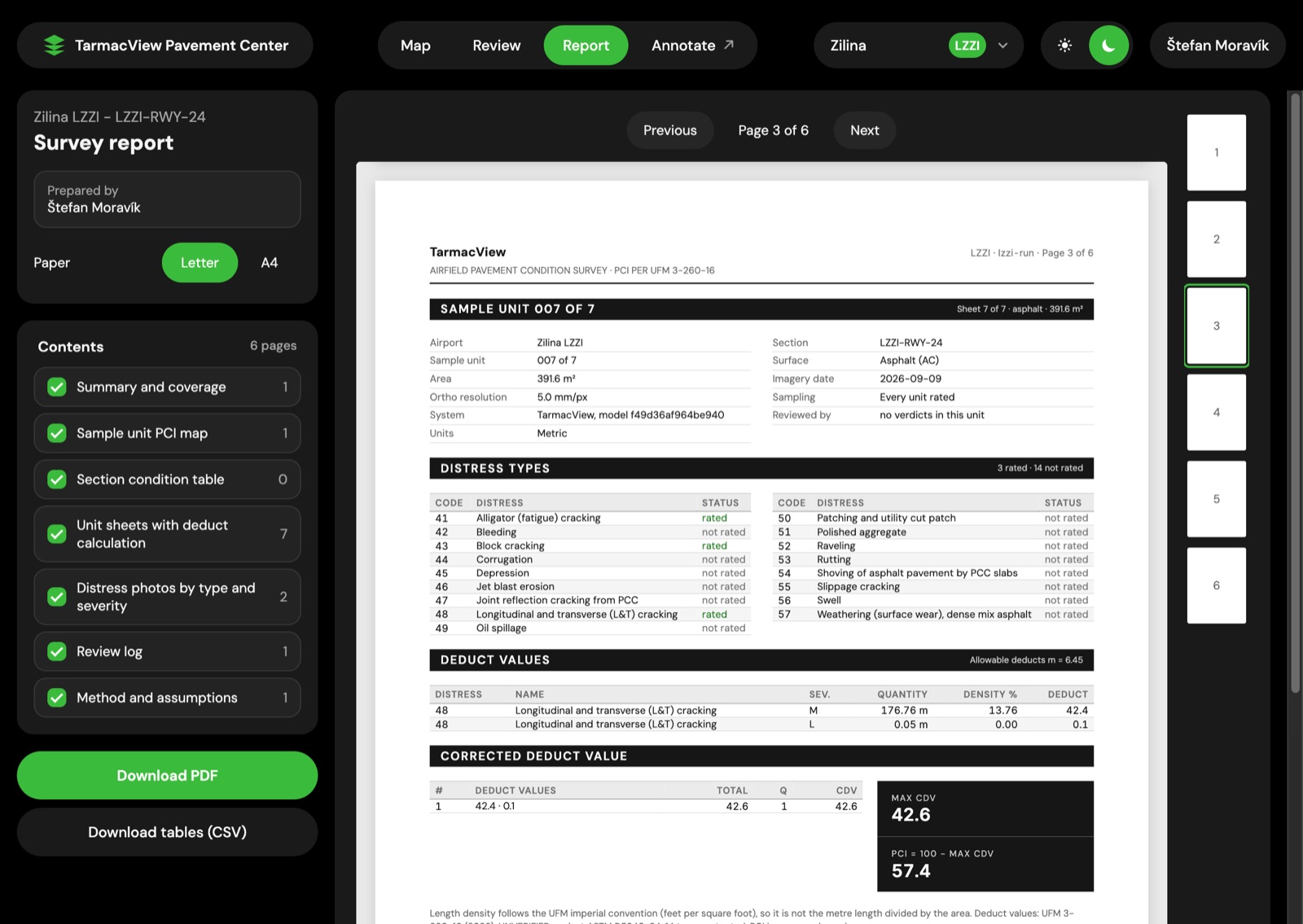
A condition sheet for a sample unit. The deducts, the corrected deduct value and the PCI are on the page, not in a spreadsheet nobody opens.
Keep the position of every crack
Each distress keeps its map position, length and width. A repeat survey therefore shows how each crack grows, not just that the section PCI fell by two points. The GeoJSON inventory and the PCI tables are keyed to your section and sample-unit IDs, so two surveys read side by side.
How close to the manual
The check that matters most to an engineer is whether the arithmetic matches the manual. UFM 3-260-16 carries worked examples for asphalt and for concrete. The software rated them and the PCI came within 1 point of the printed answer in both cases.
A section surveyed again on the same runway repeated within 1 point. An orthomosaic built from drone positions, which is six times faster than photogrammetry, also held the PCI within 1 point.
The crack model is built on the public DINOv2 backbone with our own crack layers. On held-out hand-checked tiles, the model reaches more than 90 % of the agreement between two human annotators. On 60 crack-free concrete tiles, our two crack models combined raised no false detection on 57.
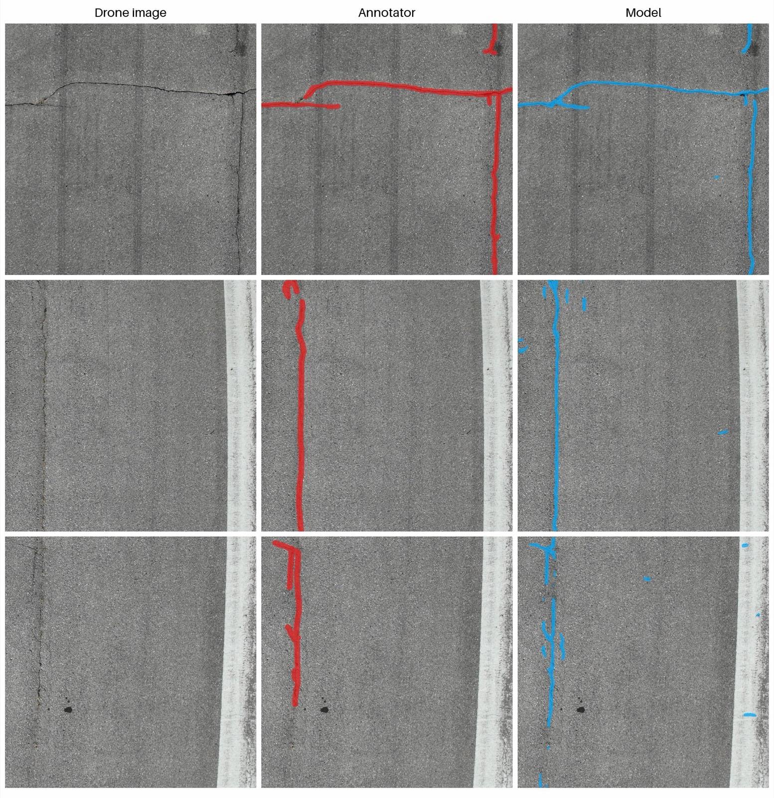
Held-out asphalt tiles: drone image, annotator (red), model (blue).
These are results on the manual’s examples and on our own flights at Slovak airfields. A trained PCI inspector has not yet rated our sections side by side with the software. That comparison is the evidence a programme should ask for, and the early access is the way to run it on your own sections.
Runway time is the flight
The aircraft launches from the shoulder. Nothing touches the pavement, and the runway reopens as soon as the aircraft lands. Capture time depends on the smallest crack you want rated. For one aircraft over 1 km of a 45 m wide runway:
- 4 minutes for cracks from 10 mm
- 13 minutes for cracks from 5 mm
- 45 minutes for the full survey at 1 mm per pixel, with cracks from 2 mm
More aircraft cut these times. A section can be flown in a window between movements, and the processing happens afterwards, off the runway.
On the installation, with no cloud
The software runs on a MacBook or a PC with a graphics card, on site. About 20 minutes passes from image capture to the PCI report for 1 km of runway at 5 mm per pixel. On a MacBook, the 1 mm survey takes about 30 minutes per 100 m and the 5 mm survey about 2 minutes. Nothing leaves the installation.
The mission planner is drone agnostic: DJI, MAVLink (PX4 and ArduPilot) and UgCS. TarmacView j. s. a., Bratislava, holds the NATO NCAGE code 0181M. Our partner operators keep a fleet of Blue UAS cleared aircraft for installations that need one. TarmacView itself is not on the Blue UAS list. The programme page is the DIU announcement of the move to DCMA .
The same platform already runs PAPI and navigation aid inspection, so the airfield lighting and the pavement come from one planner and one record.
An analyst reviews, and the model learns
The report never waits for review. The PCI is computed from the detections as they are. Review then improves it.
Each detection is shown next to the cracks that look like it. The analyst marks a sealed crack, a joint, vegetation, paint or a stain, and one save applies the verdict to every similar detection. The PCI per unit updates on screen. Sealant and paint edges read as cracks, so this is where they get cleared, in minutes. Every verdict becomes a training label for the next model.
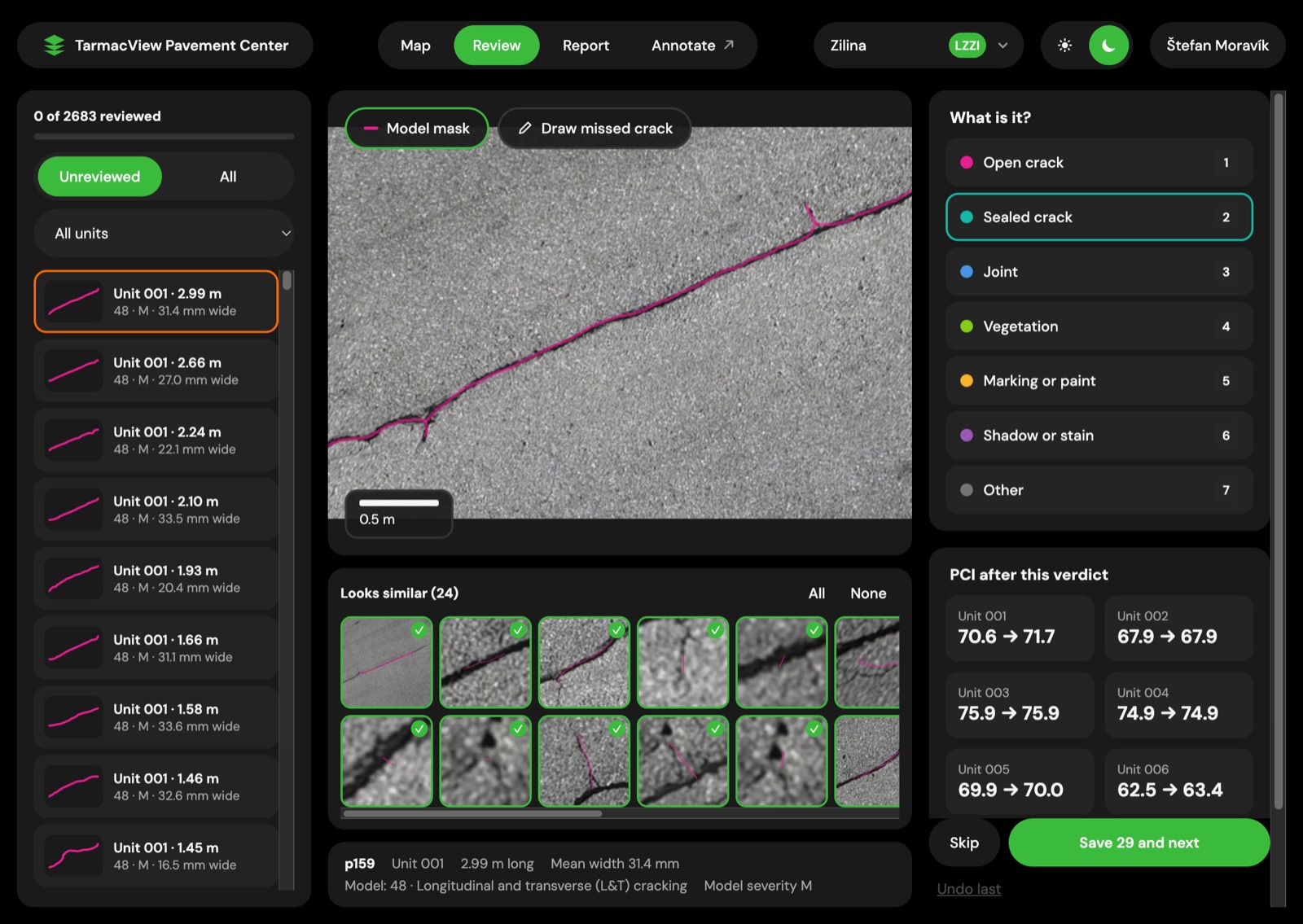
One verdict, 24 similar cracks, one save. The PCI per unit updates.
What the programme gets back
- A GeoJSON inventory of every distress with position, length and width
- PCI per sample unit and per section, keyed to section and sample-unit IDs
- CSV tables for the programme’s own spreadsheets and databases
- A PDF condition sheet per unit with the deduct calculation
- A report listing the types rated and not rated
PAVER import is not built. Moving the results into PAVER is a manual step today, and the IDs are kept stable so that step stays small. Results loading into PAVER and GIS is where the service is going.
A walked D5340 survey and a drone PCI survey
| Question | Walked D5340 survey | Drone PCI survey |
|---|---|---|
| Coverage | The sample units chosen by the sampling rules, with the section inferred from them | Every sample unit, from imagery of every square metre at 1 to 5 mm per pixel |
| Distress types | The full D5340 catalogue, identified by the inspector | Cracking and joint and corner spalling rated with severity, a classifier recognising all 33 types, and a report of what was not rated |
| Rater dependence | The rating rests on the inspector's eye and on hand-added deducts | The same rules on every unit, with the deduct calculation visible per unit and an analyst review on top |
| Runway time | The runway is closed while people walk the units | The flight itself. 4 to 45 minutes per kilometre for one aircraft, and nothing touches the pavement |
| Repeatability | Depends on the same units, the same catalogue and a similar eye each cycle | Section PCI repeated within 1 point on the same runway, with every crack keeping its position |
| Record | A condition sheet per sampled unit and a section PCI | A GeoJSON inventory, PCI per unit and section, CSV tables and a PDF sheet per unit |
| Formal requirement | The record where a requirement names a walked survey signed by a trained inspector | Not a substitute where a requirement names that survey, until a side-by-side comparison exists |
How a survey runs
From the section map to the reviewed PCI report
- 01
Agree the section map with the installation
Start from the installation's existing network, branch and section map in PAVER. Agree the surfaces in scope, the sample units and their IDs before any capture.
WhyThe PCI is a statement about a defined section, so the sections cannot move between surveys.
Done whenA section and sample-unit map that this survey and every repeat will use.
If notWhere no map exists, divide by construction history and use, and write the IDs down.
- 02
Choose the crack size and the aircraft
Pick 10 mm, 5 mm or 2 mm cracks. Plan the mission for a DJI, MAVLink (PX4 or ArduPilot) or UgCS aircraft, or a partner operator's Blue UAS cleared aircraft.
WhyThe smallest crack you want rated sets the pixel size, and the pixel size sets the flight time.
Done whenA mission that covers the full width of each surface at the chosen resolution.
If notIf time is short, fly the 5 mm survey now and the 1 mm survey on the sections that need it.
- 03
Fly from the shoulder
Launch from the shoulder in a window between movements, in daylight, on a dry surface where the window allows.
WhyRunway time should be the flight, with nothing on the pavement.
Done whenEvery surface is covered with a position on every image, and the runway reopens as soon as the aircraft lands.
If notSnow, sand or standing water on a section means that pass is flown again once the surface is clear.
- 04
Process on the installation
Run the software on a MacBook or a PC with a graphics card, on site. Build the orthomosaic, find and measure each distress, and rate it by the D5340 definitions.
WhyData stays where the rules want it, and the result is ready the same day.
Done whenAbout 20 minutes from capture to report for 1 km at 5 mm per pixel.
If notA disputed crack is checked against the stored images, not flown again.
- 05
Read the PCI report
Open the PCI per sample unit and section, the condition sheet with the deduct calculation, and the list of types rated and not rated.
WhyThe report is the first result, and it never waits for review.
Done whenA PCI for every sample unit, with the arithmetic open to check.
If notAn unrated type biases the PCI upward. Note which types are missing before the figure is used.
- 06
Review with an analyst
Check each detection next to the cracks that look like it. Mark sealed crack, joint, vegetation, paint or stain, and save once for all similar detections.
WhySealant, joints, paint and stains read as cracks, and a verdict clears them for good.
Done whenThe reviewed PCI per unit, with every verdict kept as a training label.
If notUnreviewed detections stay in the report as they are. Review can be done later.
- 07
Load the results into the programme
Take the GeoJSON inventory, the PCI tables and the PDF sheets into your GIS and your management system by hand. Keep the section and sample-unit IDs unchanged.
WhyThe survey is only useful once it reaches the work plan.
Done whenThe survey sits in the programme keyed to the same IDs as the last one.
If notPAVER import is not built. If the manual step is too heavy, ask for the CSV layout your system reads.
Where it is going
These are directions, not features you get today.
- Every D5340 type rated automatically with severity, and debris flagged in the same pass
- Results loading into PAVER and GIS
- Crack growth forecasts from repeat surveys
- Crack depth from angled photos
- Crater and spall depth and volume, for rapid damage assessment after an attack
- Drone docks at the base
- Processing on the installation’s own secure government cloud
Honest limits
Wind, temperature and rain limits are the aircraft maker’s. The survey needs daylight and prefers a dry surface. Sealant and paint edges read as cracks and are cleared in review in minutes. Nothing below the surface is seen, and the service measures no structural capacity and no friction.
The Air Force runs its pavement evaluation programme under AFI 32-1041. Which survey a programme requires, and how often, is set by that instruction and by your own command, not by this page.
Ing. Jaroslav Šulc brings 25 years in flight inspection to the team and approves the procedures and the methodology.
Objections worth raising before an evaluation
“Our raters are trained and the method works.” It does, and the walked survey remains the record. The drone adds the units a sample leaves out and a calculation you can read.
“The data cannot leave the installation.” It does not. The software runs on a laptop on site, and no cloud is needed.
“It has to load into PAVER.” Not yet. The IDs and the CSV tables are shaped for it, and loading is on the way.
Related tasks
If the question is the service itself, the pavement condition assessment page describes it while it is in development. If it is the same survey for a European airport authority, see government airport pavement condition . For allied airfields rated by different national methods, see NATO airfield pavement condition . To run a drone PCI against your own walked sections, contact TarmacView .
Frequently Asked Questions
- Does a drone PCI replace the walked D5340 survey?
- Not where a requirement names a walked survey signed by a trained PCI inspector. A trained PCI inspector has not yet rated our sections side by side with the software, and until that comparison exists the walked survey is the record. What the drone adds is a rating of every sample unit, a deduct calculation you can read per unit, and a survey that costs the runway only the flight. Evaluation teams can run both on the same sections and compare.
- How close is the PCI to the UFM 3-260-16 worked examples?
- Within 1 point, on asphalt and on concrete. The software was run on the worked examples in UFM 3-260-16 and the PCI it computed was compared with the printed answer. A section surveyed again on the same runway repeated within 1 point. An orthomosaic built from drone positions, six times faster than photogrammetry, also held the PCI within 1 point. These are results on our own flights and on the manual's examples. They are not a comparison with an inspector.
- Which distress types are rated?
- Alligator, block, longitudinal and transverse cracking on asphalt, and linear cracking with joint and corner spalling on concrete, are rated automatically with severity from measured crack width. A classifier labels each image tile with the other D5340 types and already recognises all 33. The catalogue is transcribed from UFM 3-260-16. The report lists the types rated and the types not rated, because an unrated type biases the PCI upward.
- Can results go into PAVER?
- Not directly. PAVER import is not built. What the service writes today is a GeoJSON inventory, PCI per sample unit and per section keyed to your section and sample-unit IDs, CSV tables and a PDF condition sheet per unit. Moving those into PAVER is a manual step. Results loading into PAVER and GIS is where the service is going, and the IDs are kept stable now so that step stays small.
- Does it run on the installation with no cloud?
- Yes. Processing runs on a MacBook or a PC with a graphics card, on site. About 20 minutes passes from image capture to the PCI report for 1 km of runway at 5 mm per pixel. On a MacBook the 1 mm per pixel survey takes about 30 minutes per 100 m and the 5 mm survey about 2 minutes. Imagery and results stay on the machine. Processing on a secure government cloud is a direction, not a requirement.
- Which aircraft does it fly, and what about Blue UAS?
- The mission planner is drone agnostic and plans for DJI, MAVLink (PX4 and ArduPilot) and UgCS aircraft. TarmacView itself is not on the Blue UAS list. Our partner operators keep a fleet of Blue UAS cleared aircraft and fly the survey for installations that need one. TarmacView j. s. a. in Bratislava holds the NATO NCAGE code 0181M. Wind, temperature and rain limits are the aircraft maker's.
- What stops a survey?
- Anything that hides the surface. Snow, sand or standing water cover the distress, and the pass is flown again once the surface is clear. The survey is flown in daylight, preferably on a dry surface. Sealant and paint edges read as cracks, and the analyst clears them in review in minutes. The service sees nothing below the surface and measures no structural capacity or friction.
References
- astm-d5340
- ASTM D5340-24, Standard Test Method for Airport Pavement Condition Index Surveys ASTM International
- ufm-3-260-16
- UFM 3-260-16, Condition Surveys of Operating Surfaces US Department of Defense, Unified Facilities Manual
- afi-32-1041
- AFI 32-1041, Pavement Evaluation Program US Air Force
- blue-uas-dcma
- DIU's Blue UAS list to transition to DCMA Defense Innovation Unit