Airport Pavement Condition Surveys for Government and State Airports
One published PCI method, flown by drone, gives a public airport owner a pavement rating every airport can be ranked on. Early access, data stays with the owner
- 01 No EU rule requires a PCI. The rules ask for inspection and maintenance of movement area surfaces, and a PCI per sample unit is evidence that maintenance is planned on the same measure at every airport.
- 02 ASTM D5340 is a neutral published method used by the FAA and the US DoD, not a vendor index, so a tender is not tied to one supplier's scale.
- 03 Every sample unit is rated, not a sample of units, and the same software rates every airport, so the variance between inspectors, sites and tender rounds drops out of the ranking.
- 04 The runway reopens as soon as the drone lands. Results are GeoJSON, PDF and CSV on the owner's own hardware, with no cloud in the processing path.
- 05 Repeat surveys keep each crack's position, length and width, so growth is measured and repair can be planned before failure. This is early access, and a certified inspector has not yet rated our sections side by side.
On this page · 16 sections
Who runs into this
An owner of several airports manages a network, not a pavement. A ministry, a regional authority or a state airport company holds a runway at one airport and an apron at the next, each with its own age, traffic and repair history. One capital plan covers them all. The question is which sections go first, and the answer has to hold up in front of an auditor and a budget committee.
Three things get in the way.
- Condition data comes from walked visual inspections. Two inspectors rate the same crack differently, and one inspector rates it differently two years apart.
- Each airport was surveyed in a different year, by a different contractor, to a different scale.
- A walked survey rates the units a person reaches and leaves the rest to be inferred.
The pavement condition assessment is the service behind this page. It is in development and offered as early access. This page sets out what it does for a public owner, and where it stops.
What the rules ask, and what they leave open
Regulation (EU) 139/2014 sets the requirements for certified aerodromes in the EU. ADR.OPS.C.010 covers pavements, other ground surfaces and drainage, and it asks for the surfaces of the movement area to be inspected and kept in a condition that supports safe operations, under a maintenance programme. ICAO Annex 14 Volume I Chapter 10 says the same thing for aerodrome maintenance, and ICAO Doc 9137 Part 9 gives the guidance behind it.
No EU rule names a Pavement Condition Index. The owner decides how the maintenance programme is evidenced, and most fill that space with a walked inspection written up in the inspector’s own words.
A PCI fills it with a number. It scores a sample unit from 0 to 100 from the distresses found on it, and a section is the area-weighted result of its units. The figure does not satisfy a regulation, because none asks for one. It gives the programme a measure a decision can rest on. The PCI explainer shows how the number is built.
What the survey gives a public owner
- Resolution
- Every square metre imaged at 1 to 5 mm per pixel, not a sample of units.
- Rating
- A PCI per sample unit and per section, by the ASTM D5340 definitions, the same at every airport.
- Closure
- The aircraft launches from the shoulder, nothing touches the pavement, and the runway reopens as soon as it lands.
- Where it runs
- A MacBook or a PC with a graphics card on your own hardware, with no cloud service in the processing path.
- Output
- A GeoJSON inventory, PDF condition sheets with the deduct calculation, and CSV tables.
- Aircraft
- Mission export for DJI, MAVLink and UgCS, so the tender does not name one brand.
- Rated today
- Alligator, block, longitudinal and transverse cracking on asphalt, linear cracking and joint and corner spalling on concrete, each with severity from measured width.
- Status
- In development, offered as early access.
Budget evidence that compares across airports
A capital plan needs a figure that means the same thing at the first airport and at the last. A walked inspection cannot promise that. The rating depends on who walks and on the day, so a comparison between two airports compares two inspectors as much as two pavements.
The drone survey takes the inspector out of the rating. The software finds each distress, measures its length in metres and its width in millimetres, and rates it by the D5340 definitions. The same rule runs on every pavement, so a change in the figure is a change in the pavement and not in the person.
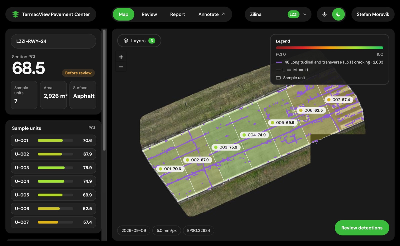
A runway section at Žilina (LZZI), Slovakia. Seven sample units are coloured by PCI, the section PCI is 68.5, and every crack is drawn where it lies.
That map is the budget exhibit. A planner sees which units are worst, and an auditor sees that the figure comes from the drawn cracks.
One honest limit belongs here. The report lists every distress type it does not rate, and an unrated type biases the PCI upward. The rule is the same at every airport, so the ranking stays consistent, but the absolute figure is an upper bound where unrated distress is present.
A neutral method, not a vendor index
ASTM D5340 is a published standard. The FAA uses it for airport pavements, and the US DoD applies it through UFM 3-260-16, whose distress catalogue is aligned with it. TarmacView follows the D5340 definitions and its catalogue is transcribed from UFM 3-260-16. The PCI of the UFM 3-260-16 worked examples is reproduced within about 1 point.
For a public owner the figure is yours. Any consultant who knows the ASTM D5340 method can read a unit sheet, check the deducts and challenge the result. A later tender can ask for the same method from a different supplier, and the old and new surveys stay comparable. A vendor index makes the next tender a negotiation with the last winner.
The same rating whoever flies
A programme that spans several airports and years will see several operators and several tender rounds. The rating does not depend on any of them. The mission planner is drone agnostic, with export to DJI, MAVLink and UgCS, so the tender asks for flights and not for one aircraft brand. The software rates the images the same way, so the figure from the first round and the figure from the fifth are made by the same rule.
Wind, temperature and rain limits are the aircraft maker’s. A survey flies in daylight, preferably over a dry surface. Any asphalt or concrete not covered by snow, sand or water can be surveyed, on an airport the operator knows or one it has never seen.
The runway reopens when the drone lands
The aircraft launches from the shoulder. Nothing touches the pavement and no inspector walks the surface. Runway time is the flight itself, so the runway reopens as soon as the drone lands. One aircraft covers 1 km of a 45 m wide runway in about 4 minutes for cracks from 10 mm, 13 minutes for cracks from 5 mm, and 45 minutes for the full 1 mm per pixel survey with cracks from 2 mm, and more aircraft cut these times. The software works on the stored images after the flight, off the runway, and a 5 mm report for 1 km is ready about 20 minutes later.
Data stays with the owner
The processing runs on a MacBook or a PC with a graphics card, on your own hardware, with no cloud service in the processing path. The imagery stays with the owner unless the owner sends it.
The output is three open formats. A GeoJSON inventory holds every distress with its map position, length and width, plus the PCI per sample unit and section. A PDF condition sheet per unit shows the deduct calculation, so a reader can follow the arithmetic. CSV tables carry the numbers into the owner’s own tools. All three open in standard software, so the record moves to another system or supplier without an export step that belongs to us. The offline workflow describes an airfield with no network in full.
Analyst review keeps the figure honest
The first pass is automatic and the report never waits for review. In review, the analyst sees each detection next to the cracks that look like it. A sealed crack, joint, vegetation, paint or stain is marked in one save, and the PCI of the unit changes at once. Marking one sealed crack can clear 24 similar ones in the same save. Every verdict is saved as a labelled example for retraining.
From repair after failure to planned repair
One survey is a snapshot. Two surveys are a trend. Every distress keeps its map position, its length in metres and its width in millimetres, so a repeat survey of the same pavement shows how each crack has grown. Concrete fits its slab grid, so a slab keeps its identity between surveys.
That is what moves a maintenance plan from repair after failure to planned repair. A crack that opened by a few millimetres in a year sits on a different curve from one that did not move, and a programme that sees the growth can seal on a plan. A growth forecast is in development. What exists today is the measured growth between two surveys.
How a network survey runs
The first step sets the section map every later survey reuses, so it is the one worth getting right.
From a network of airports to a ranked set of section PCIs per airport
- 01
Scope the network
List the airports, runways, taxiways and aprons in scope, and the pavement type of each. Agree what a ranked result must show, for example a section PCI per airport and a worst-first list for the whole network.
WhyA ranking only works if every airport is rated on the same terms.
Done whenA scope note naming the surfaces, the output formats and the person who owns the data.
If notIf the pavement type of a surface is unknown, record it as unknown and confirm it on the first flight.
- 02
Fix the sections and the sample units
Divide each pavement into sections by construction history and use, and into sample units. Keep the owner's existing section identifiers where they exist.
WhyA later survey can only be compared if the sections do not move.
Done whenA section map for every airport that every later survey will use.
If notWhere no map exists, divide by construction history and traffic, and record the reasoning.
- 03
Fly each airport
Fly the agreed surfaces in daylight at 1 to 5 mm per pixel, from the shoulder, in the window the airport allows. Any aircraft that exports from the mission planner will do.
WhyImagery at a known resolution is the evidence behind every figure.
Done whenEvery surface is covered, with a position on every frame.
If notWater, snow or sand on a section means that section is flown again once the surface is clear.
- 04
Process on your own hardware
Build the orthomosaic, detect and measure every crack, and rate the sample units by the D5340 definitions on a MacBook or a PC with a graphics card.
WhyThe orthomosaic, the detections and the rating are produced on site, so no imagery has to leave.
Done whenA GeoJSON inventory, a PCI per sample unit and section, and a PDF condition sheet per unit.
If notA disputed unit is checked against the stored frames and not flown again.
- 05
Review and read the not-rated list
An analyst clears false detections in review, and reads the report's list of types rated and not rated for every unit.
WhySealant, paint and joints read as cracks, and unrated types bias the PCI upward.
Done whenA reviewed PCI per unit, with the unrated types named.
If notWhere a type is not rated and likely to matter, walk that unit and record it beside the figure.
- 06
Rank the sections and repeat
Order the sections by PCI across the airports, and read the worst-first list against the capital plan. Fly the same sections again on the next cycle and compare crack length and width.
WhyThe ranking is the budget evidence, and the repeat shows growth.
Done whenA ranked set of section PCIs per airport, and a record that can be repeated.
If notIf a section changed between rounds, record the change and keep the old figure beside the new one.
A walked visual inspection and a drone PCI survey
| Question | Walked visual inspection | Drone PCI survey |
|---|---|---|
| Coverage | The units a person reaches, with the rest inferred | Every square metre imaged at 1 to 5 mm per pixel, every sample unit rated |
| Inspector variance | Differs by inspector, by site and by year | One rule rates every pavement, whoever flies |
| Comparable across airports | Only when the same inspector uses the same scale | A PCI per sample unit by one published method at every airport |
| Method | The inspector's own form or an agency scale | ASTM D5340 definitions, used by the FAA and the US DoD |
| Runway closure | The runway is closed while people walk it | The runway reopens as soon as the drone lands |
| Data and lock-in | Paper or a contractor's file | GeoJSON, PDF and CSV on the owner's hardware |
| Growth between surveys | Described in words | Each crack keeps its position, length and width |
| Formal sign-off | A walked survey signed by a certified inspector, where a rule names one | Not yet a substitute where a rule names a signed walked survey |
Limits that do not move
- Daylight, and preferably a dry surface. Snow, sand and standing water hide the cracks.
- Wind, temperature and rain limits are the aircraft maker’s.
- Sealant and paint edges read as cracks. An analyst clears them in review, in minutes.
- Nothing below the surface. The survey does not measure structural capacity or friction.
- Cracking and spalling are rated automatically today. A classifier labels the other D5340 types, and the report lists every type it did not rate.
Where it is going
The direction, with no dates. Every type rated automatically with severity, debris flagged in the same pass, results loading into PAVER and GIS, crack growth forecasts, crack depth from angled photos, and drone docks at the base. None of this is built, and the survey described above does not depend on it.
Objections worth raising
“No rule asks for a PCI, so why add one?” None does. The rules ask for a maintenance programme, and a PCI gives it a figure that auditors and a capital plan can use.
“Our inspectors know the pavement better than software does.” They do, and they stay in the loop, because the analyst review is theirs. The software adds the same rule on every unit and the whole surface imaged.
“We will be tied to one drone or one supplier.” The mission export covers DJI, MAVLink and UgCS, the output is GeoJSON, PDF and CSV, and the method is published.
To test it on your own sections, contact TarmacView about early access.
Related tasks
If the question is the service itself, the pavement condition assessment page describes it while it is in development. If your airfields are rated under a NATO or national military method, the NATO airfield pavement condition page takes that angle. If the owner is a US military installation, the US military airfield pavement PCI page covers the D5340 and UFM 3-260-16 rules. For the lighter recurring look, the runway pavement check is the shorter service.
Frequently Asked Questions
- Does EU law require a PCI for our airports?
- No. Regulation (EU) 139/2014 and ICAO Annex 14 ask for the surfaces of the movement area to be inspected and kept in good condition under a maintenance programme. Neither names a PCI. A PCI is a way to give that programme a number you can compare between sections and between years. It does not replace what the rule asks for and it is not a legal requirement.
- Why use ASTM D5340 and not a vendor's own condition score?
- A published method can be read by any auditor, any consultant and any later contractor. ASTM D5340 is the airport PCI method used by the FAA, and the US DoD applies it through UFM 3-260-16. TarmacView follows the D5340 definitions. A score that only one supplier can reproduce ties the next tender to that supplier.
- How can one rating be comparable across airports flown on different days?
- The same software finds, measures and rates every distress by the D5340 definitions, so the rule does not change between airports or between tender rounds. Daylight and a dry surface matter, because the camera needs to see the cracks. Sealant and paint edges can read as cracks, and an analyst clears them in review, where each verdict shows the PCI change at once.
- Which distress types are rated today?
- Alligator, block, longitudinal and transverse cracking on asphalt, and linear cracking on concrete, each with severity from measured width. A classifier labels each tile with the other D5340 types, and an analyst confirms them. The report lists every type rated and every type not rated. An unrated type biases the PCI upward, so the report says where that applies.
- Where does the data go, and can we leave later?
- The processing runs on a MacBook or a PC with a graphics card on your own hardware, with no cloud service in the processing path. Output is a GeoJSON inventory, PCI per sample unit and per section, a PDF condition sheet per unit with the deduct calculation, and CSV tables. All three formats open in standard tools, so no export step ties you to us.
- Do we need a specific drone?
- No. The mission planner exports to DJI, MAVLink and UgCS, so an operator can fly with the aircraft they already own and a public tender does not name one brand. The pavement software works from the images and their positions. Wind, temperature and rain limits are the aircraft maker's, so they differ by aircraft.
- Can this replace our walked inspection?
- Not yet where a requirement names a walked survey signed by a certified inspector. A certified PCI inspector has not yet rated our sections side by side, and that comparison is the honest test. Until it exists, the drone survey is the whole-surface record and the ranking evidence, and your walked inspection stays where a rule names it.
References
- easa-ear-aerodromes
- Easy Access Rules for Aerodromes (Regulation (EU) No 139/2014), ADR.OPS.C.010 Pavements, other ground surfaces and drainage European Union Aviation Safety Agency
- icao-annex-14-vol-i
- Annex 14 to the Convention on International Civil Aviation, Aerodromes, Volume I: Aerodrome Design and Operations, Chapter 10 Aerodrome Maintenance International Civil Aviation Organization
- icao-doc-9137-part-9
- Doc 9137, Airport Services Manual, Part 9, Airport Maintenance Practices International Civil Aviation Organization
- astm-d5340-24
- ASTM D5340-24, Standard Test Method for Airport Pavement Condition Index Surveys ASTM International
- ufm-3-260-16
- UFM 3-260-16, Condition Surveys of Operating Surfaces US Department of Defense, Unified Facilities Manual