Inspecting an Airfield With No Internet At All
Capture, processing and the finished report can all happen on a laptop on the airfield, with nothing leaving the airport and no connectivity needed.
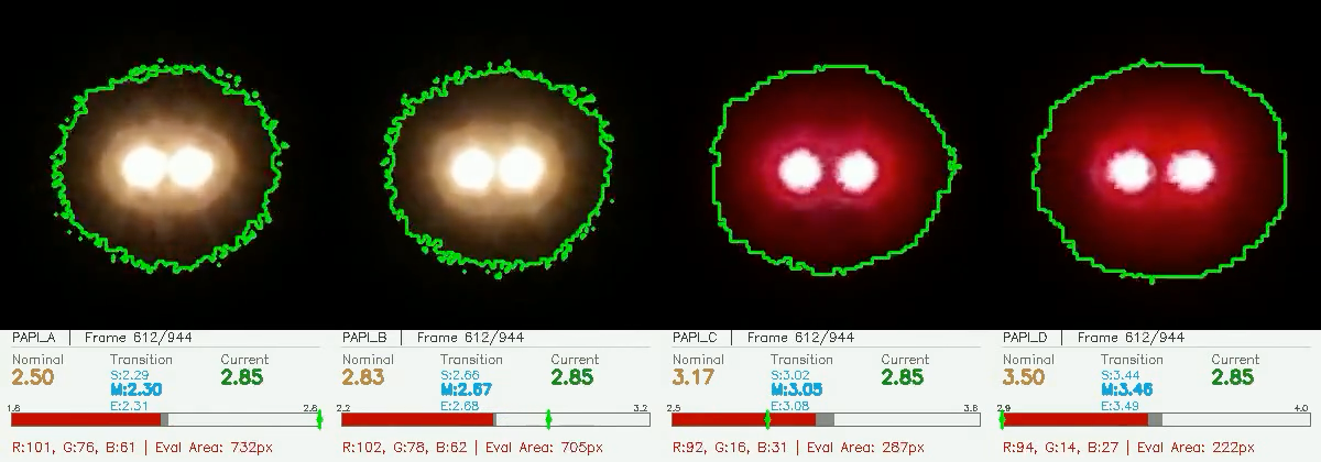 PAPI UNIT · FRAME CAPTURE
The question that comes up first
Airfields are not offices. Plenty of them have a terminal building with decent bandwidth and a runway threshold two kilometres away with none. Others have connectivity but rules that keep operational data inside the perimeter.
So the first question is usually some version of: does this thing need the internet?
No. The whole loop runs on the airfield if you want it to.
What on-site actually means
In the on-site model, a field laptop serves a local network on the airfield. The drone sends footage to the field hub over that network, the hub passes it to the laptop, and the laptop does the work. Capture, processing and report generation all happen there. Nothing is uploaded, because there is nowhere to upload to.
The hardware bar is deliberately low. Any modern laptop will do. There is no dedicated GPU, no workstation, and no rack of anything in a hut by the runway.
What you get at the end is the same regulatory-grade report the cloud model produces, built to ICAO, EASA or FAA tolerances, with the same photo and video evidence, within minutes of the last pass.
When the cloud is the better answer
The offline model is not the recommended one. It is one of two, and the right choice depends on the airport.
Running on AWS buys things a laptop cannot: heavier 3D reconstruction, historical trend analysis across campaigns, and managed access control with roles and multi-factor authentication. If your airport wants to compare this year’s angles against the last four years, that history has to live somewhere.
The link does not need to be good. Any usable connection works, including 4G or 5G from the field, because the upload happens after the flight rather than during it.
Two models, one measurement
The part worth being clear about: the deployment model changes where the computation happens and nothing else. Same computer-vision core, same tolerances, same report format, same evidence. An authority receiving the protocol cannot tell which model produced it, because there is nothing in it to tell them.
That is deliberate. Deployment is an infrastructure decision, and infrastructure decisions should not leak into measurement results.
How to pick
Two questions settle it in most cases.
If there is no usable internet at the airfield, or your data rules keep operational data on site, run on-site on the local network.
If you want managed scale, role-based access and inspection history across campaigns, run on AWS.
If the answer is somehow both, that is fine too. Deployment is agreed per airport, and TarmacView is not tied to a single hosting shape.
The technology page lays both models out side by side, or you can ask us about your airfield directly.
Founded by flight-inspection veterans who spent decades measuring PAPI lights for aviation authorities across Europe.
Learn more
Related terms
03 TERMSAutomated Drone-Based Infrastructure Inspection
Automated drone inspection uses pre-programmed flight paths, computer vision, and AI analysis to survey infrastructure assets including runways, bridges, roads, and buildings with minimal human piloting. This technology produces consistent, repeatable data for Pavement Condition Index computation, defect detection, and change monitoring across civil aviation and transportation infrastructure.
Airfield
A comprehensive glossary reference for airfield and airport infrastructure, including definitions, uses, engineering standards, and regulatory context for aviation professionals and enthusiasts.
Edge Computing for Real-Time Inspection
Edge computing performs AI inference directly on the drone, vehicle, or handheld device at the point of data capture, enabling real-time defect detection, quality filtering, and decision support without uploading to the cloud. Reduces data transmission, cuts latency, and speeds response in infrastructure inspection workflows.
Further reading
03 ARTICLES
Technology & Innovation
Cutting-edge computer vision that runs on-site or on the AWS cloud.
No More SD Cards: the Field Hub Explained
Footage moves off the drone over the airfield network automatically, so processing starts while the crew is still packing up instead of hours later.
Drone Airport Inspection: Method and Limits
How a drone inspects an aerodrome between aircraft movements: the mission profile, RTK positioning, tower coordination, the evidence chain, and where…