What is Wind Direction?
Wind Direction (Meteorology): Comprehensive Guide for Aviation, Meteorology, and Navigation
Definition and Core Concept
Wind direction is the compass direction from which the wind originates, not where it is blowing to. In aviation, meteorology, and navigation, this “from” convention is critical for understanding weather patterns, planning flight operations, and interpreting environmental changes. For example, a “west wind” comes from the west and moves eastward.
Wind direction can be expressed in:
- Compass points (N, NE, W, etc.)
- Degrees relative to true north (0°–360°)
This standardization is globally recognized and mandated by organizations like ICAO and WMO, ensuring clear communication for safety-critical industries.
Measuring and Expressing Wind Direction
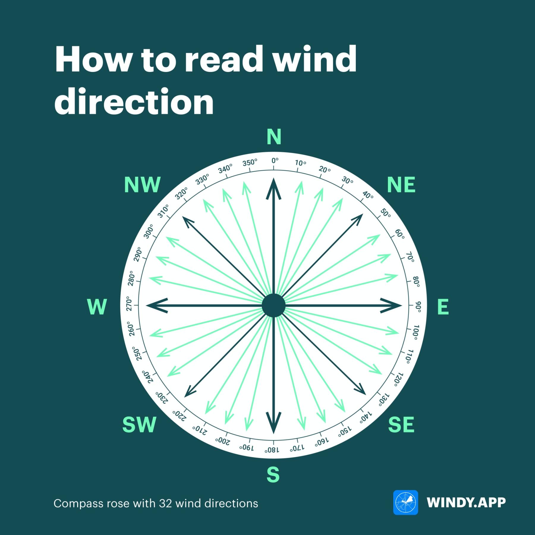
Compass Points and Degrees
Wind direction is reported using:
- Cardinal or intercardinal points: North (N), Southwest (SW), East-Northeast (ENE), etc.
- Degree system: 0°/360° (North), 90° (East), 180° (South), 270° (West), with finer increments for precision (e.g., 135° = SE).
| Compass Point | Abbreviation | Degrees |
|---|---|---|
| North | N | 0°/360° |
| North-Northeast | NNE | 22.5° |
| Northeast | NE | 45° |
| East-Northeast | ENE | 67.5° |
| East | E | 90° |
| East-Southeast | ESE | 112.5° |
| Southeast | SE | 135° |
| South-Southeast | SSE | 157.5° |
| South | S | 180° |
| South-Southwest | SSW | 202.5° |
| Southwest | SW | 225° |
| West-Southwest | WSW | 247.5° |
| West | W | 270° |
| West-Northwest | WNW | 292.5° |
| Northwest | NW | 315° |
| North-Northwest | NNW | 337.5° |
Degrees are referenced to true north unless otherwise specified (e.g., magnetic north for runway operations).
Instruments for Measuring Wind Direction
Wind Vane (Weather Vane)
A wind vane aligns with the wind, pointing toward its source. Modern versions use electronic sensors for digital readouts, vital for automated weather stations and aviation systems.
Windsock
A conical textile tube, the windsock points away from the wind’s origin. Its open end faces the wind. Widely used at airports and heliports for quick, visual wind assessment.
Combined Anemometers and Sensors
Automated systems combine wind vanes (direction) and anemometers (speed), transmitting real-time data for aviation (AWOS/ASOS) and meteorology.
Wind Rose
A wind rose graphically presents wind frequency and strength from different directions, supporting airport planning and climatological studies.
Weather Radar and Remote Sensing
Doppler radar and satellites infer wind direction aloft by tracking precipitation or cloud movement, crucial for forecasting and severe weather monitoring.
Reporting Wind Direction: Aviation and METAR Conventions
METAR Wind Reporting
- Format: “DDDSSKT” (e.g., 27015KT: wind from 270° at 15 knots)
- Gusts: “G” indicates gusts (e.g., 27015G25KT)
- Variable winds: “VRB” if direction fluctuates widely (e.g., VRB03KT)
- Calm: 00000KT for speeds ≤2 knots
Runway Operations
Runway numbers reflect their magnetic heading (e.g., runway 27 = 270°). Pilots take off and land into the wind for optimal lift and control.
ATIS and Tower Communications
Automated broadcasts (ATIS) and controllers provide wind direction and speed for pilots, essential for flight safety and performance calculations.
Station Model and Wind Barbs
Weather maps use wind barbs:
- Stem: Direction from which wind originates
- Barbs/flags: Indicate speed
Interpreting Wind Direction in Practice
- Wind vane: Arrow points to wind’s source.
- Windsock: Points where wind is going, report the opposite as the wind’s origin.
- Weather maps: Arrow base = wind’s origin, head = where it’s blowing.
- Wind rose: Longest “petal” indicates prevailing direction.
Aviation Example
A METAR of “18010KT” means wind from the south (180°) at 10 knots. Pilots select runways and approaches based on this data.
Common Pitfall:
Confusing “from” and “to” conventions can lead to critical misinterpretations, particularly in aviation and navigation.
Wind Direction vs. Wind Speed
- Wind direction: Where the wind is coming from (degrees or compass)
- Wind speed: How fast air is moving (knots, m/s, km/h, mph)
Both are reported together, e.g., “225° at 20 knots” = wind from SW at 20 kt.
Applications:
- Aviation: Headwind/tailwind and crosswind calculations for flight safety.
- Marine: Sail adjustment and course planning.
- Forecasting: Spotting weather fronts and storm movement.
Wind Rose: Visualization of Wind Direction Data
A wind rose displays the frequency and strength of winds from all directions for a specific location and period. Each “petal” shows the proportion and speed class.
Applications:
- Airport and runway orientation
- Urban design to minimize wind impacts
- Environmental studies (pollution dispersion)
Applications of Wind Direction Information
- Meteorology: Identifies air mass movement, weather changes, fronts, and pollutant spread.
- Aviation: Dictates runway use, flight planning, and safe operations.
- Marine navigation: Guides sail handling and route optimization.
- Sports and outdoor activities: Ensures safety and performance in kitesurfing, golf, paragliding, etc.
- Everyday life: Impacts gardening, event planning, and home comfort.
Common Errors and Misconceptions
- “From” vs. “To”: Always report wind as “from” the origin, not where it’s going.
- Windsock misreading: Remember, it points away from the wind’s source.
- Weather map arrows: Check the legend to confirm arrow convention.
- Calm winds: If ≤2 knots, direction is not reported.
Glossary of Related Terms
| Term | Definition |
|---|---|
| Wind Direction | Compass or degree direction from which wind is blowing. |
| Cardinal Directions | North, East, South, and West. |
| Compass Points | Named directions for detailed reporting (NNE, WSW, etc.). |
| Wind Rose | Graphical tool showing wind direction/speed frequency. |
| Wind Vane | Instrument that points into the wind’s origin. |
| Windsock | Textile tube indicating wind direction and speed visually. |
| Station Model | Weather map symbol set including wind data. |
| Wind Barb | Symbol showing wind direction (stem) and speed (barbs/flags). |
| METAR | Aviation weather report format. |
| Isobar | Line of equal atmospheric pressure on a map. |
| Sustained Wind | Average wind speed over a set period (e.g., 2 min for aviation). |
| Gust | Brief, significant increase in wind speed. |
Reading Wind Direction: Practical Steps
- Compass or wind rose: Face into the wind, your facing direction is the wind’s origin.
- Wind vane: Read the label where the arrow points.
- Windsock: Note where the sock points (direction wind is going), report the opposite as wind’s origin.
- Weather maps: Arrow base = origin, barbs = speed.
- METAR: “DDDSSKT” = direction from degrees true, speed in knots.
Example Scenarios
Aviation:
ATIS reports “Winds 270 at 12.” Pilots select runway 27 (270°) for optimal headwind.
Outdoor Sports:
Kitesurfer checks wind rose indicating SSW winds, choosing the safest launching time.
Forecasting:
Meteorologist observes wind shift from southerly to northerly, identifying a cold front’s passage.
Homeowner:
Plants windbreak on the property’s NW side, based on prevailing winds.
Frequently Asked Questions
Q: Why is wind direction always reported as “from” rather than “to”?
A: The “from” convention gives information about the origin air mass, supporting safety and clarity in aviation, meteorology, and navigation.
Q: How do I read a windsock?
A: The windsock points to where the wind is blowing, report the opposite direction as where the wind is coming from.
Q: How is wind direction reported in a METAR?
A: The three-digit group in a METAR (e.g., 270) specifies the direction, in degrees true, from which the wind is originating.
By understanding and applying the principles of wind direction measurement and reporting, you can improve safety, efficiency, and accuracy in aviation, meteorology, navigation, and outdoor activities.
Frequently Asked Questions
- Why is wind direction reported as 'from' instead of 'to'?
- Wind direction is reported as the direction from which it originates to inform users about the source air mass. This standard helps meteorologists, pilots, and mariners assess temperature, humidity, and weather changes, promoting global consistency and safety.
- How is wind direction measured and reported?
- Wind direction is measured using wind vanes, windsocks, or electronic sensors. It’s reported in compass points (e.g., NE, SSW) or degrees relative to true north (0°–360°). In aviation and METARs, direction is given in three digits (e.g., 270 for wind from the west).
- How do I interpret a windsock?
- A windsock points in the direction the wind is blowing toward. The wind direction is reported as the opposite direction, indicating where the wind is coming from. For example, if the windsock points east, the wind is from the west.
This is a reference entry. TarmacView provides drone inspection services and doesn't sell the equipment or materials described in this glossary.